Acushnet Heights Historic District
Historic districts in Bristol County, MassachusettsHistoric districts on the National Register of Historic Places in MassachusettsNRHP infobox with nocatNational Register of Historic Places in New Bedford, MassachusettsNew Bedford, Massachusetts ... and 2 more
Use mdy dates from August 2023Working-class culture in the United States

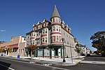
The Acushnet Heights Historic District is a predominantly residential historic district in central New Bedford, Massachusetts. It encompasses a densely-built urban area about 20 acres (8.1 ha) in size, which was developed as a working-class area, beginning in the 1860s, for the many workers in the city's factories. The district was listed on the National Register of Historic Places in 1989. It abuts the North Bedford Historic District, which is just to the south, and includes the following separately-listed properties: the Union Street Railway Carbarn, the Bradford Smith Building (since demolished), and the Dawson Building.
Excerpt from the Wikipedia article Acushnet Heights Historic District (License: CC BY-SA 3.0, Authors, Images).Acushnet Heights Historic District
Hazard Street, New Bedford
Geographical coordinates (GPS) Address Nearby Places Show on map
Geographical coordinates (GPS)
| Latitude | Longitude |
|---|---|
| N 41.647777777778 ° | E -70.931388888889 ° |
Address
Hazard Street 69;71
02740 New Bedford
Massachusetts, United States
Open on Google Maps


