place

Harvard Shaker Village Historic District

Buildings and structures in Harvard, MassachusettsChurches in Worcester County, MassachusettsHistoric districts in Worcester County, MassachusettsHistoric districts on the National Register of Historic Places in MassachusettsNRHP infobox with nocat
National Register of Historic Places in Worcester County, MassachusettsShaker communities or museumsUse mdy dates from August 2023
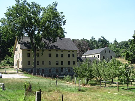
South Family Building, Harvard Shaker Village MA

Harvard Shaker Village Historic District is a historic former Shaker community located roughly on Shaker Road, South Shaker Road, and Maple Lane in Harvard, Massachusetts. It was the second oldest Shaker settlement in Massachusetts and the third oldest (after New Lebanon (1787) and Hancock, Mass (1790)) in the United States.

Excerpt from the Wikipedia article Harvard Shaker Village Historic District (License: CC BY-SA 3.0, Authors, Images).

Harvard Shaker Village Historic District
Shaker Road,

Geographical coordinates (GPS) Address Website Nearby Places
placeShow on map

Wikipedia: Harvard Shaker Village Historic DistrictContinue reading on Wikipedia

Geographical coordinates (GPS)

Latitude Longitude
N 42.5325 ° E -71.559166666667 °
placeShow on map

Address

Holy Hill (A7)

Shaker Road
01451
Massachusetts, United States
mapOpen on Google Maps

Website
harvard-trails.com

linkVisit website

South Family Building, Harvard Shaker Village MA
Share experience

Nearby Places

Ayer station
Ayer station

Ayer station is an MBTA Commuter Rail station located off Main Street (Route 2A/111) in the Ayer Main Street Historic District of Ayer, Massachusetts. It serves the Fitchburg Line. There are three tracks through the station, two of which are served by a pair of low-level side platforms, which are not accessible. There is a shelter on the inbound platform. Ayer has been a major railroad interchange since the Fitchburg Railroad opened through South Groton in 1845, followed by the Stony Brook Railroad, Worcester and Nashua Railroad, and Peterborough and Shirley Railroad in 1848. The original depot was replaced with a union station with a large trainshed in 1848. Land speculation and industrial development spurred by the railroad access expanded the tiny farm village into the independent town of Ayer. A new station was constructed in 1896. By 1900, the town was served by five lines all controlled by the Boston and Maine Railroad, with service to Boston, Worcester, and Lowell plus New York, New Hampshire, and Maine. Passenger service ended on all of the lines except the Fitchburg mainline between 1931 and 1961. After a brief disruption in early 1965, the Massachusetts Bay Transportation Authority began subsidizing commuter rail service to Ayer as part of what would become the Fitchburg Line. The station and part of the line was closed in 1975, but reopened in 1980. CSX Transportation also runs freight trains through the town to various destinations. Planning began in 2003 for a parking structure to serve park-and-ride commuters at the station. After delays caused by disagreements with a property owner, the property to ensure a public access route to the station was acquired by the town in June 2016, allowing the parking expansion to proceed. The garage opened in 2019, with improvements to the station entrance constructed in 2020–21.

Harvard Center Historic District

The Harvard Center Historic District is a historic district encompassing the traditional village center of Harvard, Massachusetts, USA. The district is centered on the town common, a triangular grassy space bounded by Elm Street, Still River Road, and Ayer Road. The common is ringed by residences, civic and religious buildings, and a small commercial area. The common was laid out when the town was founded in 1732, and has grown, mainly in periods of growth at the late 18th and late 19th/early 20th centuries. Most of the village's buildings post-date 1831. The district was added to the National Register of Historic Places in 1997.The historic district is roughly cruciform in shape, radiating out from the common along Still River Road (west), Massachusetts Avenue (Massachusetts Route 111) to the north and south, and Oak Hill Road and Old Littleton Road to the east. It covers about 125 acres (51 ha), and includes 59 historically significant houses, that range in architectural styles and age from the 18th to 20th centuries. The main civic buildings are located at the northern end of the common, and include a stone animal pound, a small powder house, and the 1872 Gothic Revival town hall, which stands next to an older (1828) Greek Revival frame building, now a residence, that also served as town hall.The district is home to two church buildings: the 1867 Colonial Revival First Congregational Church, set on the location of the town's first colonial meeting house, and the 1840 Methodist meeting house, now a private residence at 13 Massachusetts Avenue. Two of its architecturally most sophisticated buildings are the Bromfield School (1878, Romanesque Revival) designed by Peabody & Stearns, and the public library (1886, also Romanesque) designed by William Channing Whitney.