place

Corby Glen railway station

1852 establishments in EnglandDisused railway stations in LincolnshireFormer Great Northern Railway stationsLincolnshire railway station stubsPages with no open date in Infobox station
Railway stations in Great Britain closed in 1959Railway stations in Great Britain opened in 1853Use British English from August 2015
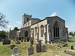
Corby Glen station site geograph 3248751 by Ben Brooksbank

Corby Glen railway station was a station on the Great Northern Railway main line serving Corby Glen, Lincolnshire. It was west of the village on the Melton Mowbray road, and was originally named just Corby, but was renamed to avoid confusion with Corby station on the Midland Railway in Northamptonshire. The station closed in 1959.

Excerpt from the Wikipedia article Corby Glen railway station (License: CC BY-SA 3.0, Authors, Images).

Corby Glen railway station
Station Road, South Kesteven Corby Glen

Geographical coordinates (GPS) Address Nearby Places
placeShow on map

Wikipedia: Corby Glen railway stationContinue reading on Wikipedia

Geographical coordinates (GPS)

Latitude Longitude
N 52.808333333333 ° E -0.53861111111111 °
placeShow on map

Address

Station Road

Station Road
NG33 4LB South Kesteven, Corby Glen
England, United Kingdom
mapOpen on Google Maps

Corby Glen station site geograph 3248751 by Ben Brooksbank
Share experience

Nearby Places

Northampton Sand Formation

The Northampton Sand Formation, sometimes called the Northamptonshire Sand, is a Middle Jurassic geological formation which is placed within the Inferior Oolite Group. It was formerly worked extensively in Northamptonshire for its ironstone. The Northampton Sand Formation constitutes the lowest part of the Inferior Oolite Group and lies on the upper Lias clay. It attains a maximum thickness of up to 21 metres (69 ft) to the north and west of Northampton where it lies in a subterranean basin. In the south, it fades out around Towcester. Northward from the edge of the basin in the upper Lias, under Northampton, it lies progressively lower beneath the Jurassic Lincolnshire limestones. A little to the north of Corby Glen (grid reference TF0027) it is at about 50 metres (160 ft) from the surface. It fades out under north Lincolnshire as the strata rise towards the Market Weighton Axis. The formation to dates to the Aalenian, and predominantly consists of sandy ironstone, which when freshly exposed is greenish-grey in colour, which weathers to limonitic brown sandstone. It formed in an extensive, shallow sea on the northwestern margin of the London-Brabant Massif. Dinosaur remains are among the fossils that have been recovered from the formation, although none have yet been referred to a specific genus. A species of horseshoe crab, Mesolimulus woodwardi has been described from the formation.The formation is a signficiant emitter of radon gas.