Abbey River
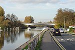
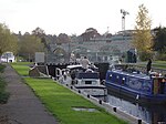
The Abbey River is a right-bank backwater of the River Thames in England, in Chertsey, Surrey — in the town's northern green and blue buffers. The L-shaped conduit adjoins mixed-use flood plain: water-meadows landscaped for a golf course, a motorway and a fresh water treatment works on the island it creates, Laleham Burway to its east and north in turn. Its offtake from the Thames is at the apex of Penton Hook, Staines upon Thames below its lower weir close to the Chertsey-Thorpe boundary in the Borough of Runnymede. Its outfall is the weir pool of Chertsey Lock back into the Thames, visible from Chertsey Bridge. Under the "River Thames Scheme", proposed by the Environment Agency, a fish pass will be installed on the Abbey River and the riverbed will be lined with gravel to provide additional habitats for spawning. A new flood relief channel, intersecting the river, will be constructed to improve the drainage of floodwater from the Abbey Meads to the Thames.
Excerpt from the Wikipedia article Abbey River (License: CC BY-SA 3.0, Authors).Abbey River
Thames Side, Borough of Spelthorne
Geographical coordinates (GPS) Address Nearby Places Show on map
Geographical coordinates (GPS)
| Latitude | Longitude |
|---|---|
| N 51.392777777778 ° | E -0.48888888888889 ° |
Address
Thames Side
KT16 8LD Borough of Spelthorne
England, United Kingdom
Open on Google Maps


