Falkenfelsen
Geography of the Black ForestLandforms of Baden-WürttembergRock formations of Germany

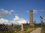
The Falkenfelsen (Falcon Rock) is a granite rock formation in the Northern Black Forest of Germany's Baden-Württemberg state. One side of the formation is a cliff about 200 feet (61 m) high. From the Schwarzwaldhochstrasse (Black Forest Highway), two hiking trails lead through the formation and end at the shelter Herta-hut. The platform has a view over the northern Black Forest, with the Hornisgrinde in the south, Bühlerhöhe in the northeast and the valley of the Upper Rhine on the west.
Excerpt from the Wikipedia article Falkenfelsen (License: CC BY-SA 3.0, Authors, Images).Falkenfelsen
Sandstraße, Vereinbarte Verwaltungsgemeinschaft Bühl
Geographical coordinates (GPS) Address Nearby Places Show on map
Geographical coordinates (GPS)
| Latitude | Longitude |
|---|---|
| N 48.67 ° | E 8.222 ° |
Address
Hertahütte
Sandstraße
77815 Vereinbarte Verwaltungsgemeinschaft Bühl (Bühl)
Baden-Württemberg, Germany
Open on Google Maps


