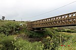
Gesher Bnot Ya'akov ( Hebrew: גשר בנות יעקב, Gesher Bnot Ya'akov; translation: Daughters of Jacob Bridge Arabic: جسر بنات يعقوب, Jisr Benat Ya'kub) is a bridge that spans the last natural ford of the Jordan River at the southern end of the Hula Basin between the Korazim Plateau and the Golan Heights. It has been a crossing point for thousands of years.
Within the vicinity of the bridge is the location of a well known Paleolithic archaeological site with Acheulean artifacts, dating to around 780,000 years ago.
The Crusaders called the site Jacob's Ford. The medieval bridge was replaced in 1934 by a modern bridge further south during the draining of Lake Hula by the Palestine Land Development Company.Located southwest of the bridge are the remains of a Crusader castle known as Chastellet and east of the bridge are the remains of a Mamluk khan (caravanserai).
The bridge is now part of Highway 91 and straddles the border between the Galilee and the Golan Heights (which was annexed by Israel in 1981). It is of strategic military significance as it is one of the few fixed crossing points over the upper Jordan River that enable access from the Golan Heights to the Upper Galilee.
The caravan route from China to Morocco via Mesopotamia and Egypt used this crossing. It was part of the ancient highway recently dubbed "Via Maris", which was strategically important to the Ancient Egyptians, Assyrians, Hittites, Jews, Saracens (early Muslims), Crusaders, Ayyubids, Mamluks, Ottomans, and modern inhabitants and armies who crossed the river at this place. The Crusaders built a castle overlooking the ford which threatened Damascus which was destroyed by Saladin in 1179 in the Battle of Jacob's Ford. The old arched stone bridge marked the northern limit of Napoleon's advance in 1799.


