place

Barlin Acres

Demolished buildings and structures in MassachusettsFederal architecture in MassachusettsHouses in Worcester County, MassachusettsHouses on the National Register of Historic Places in Worcester County, Massachusetts
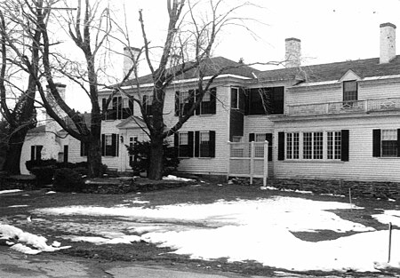
BoylstonMA BarlinAcres

Barlin Acres (or the Keyes-Dakin House) was an historic house located on what is now East Temple Street in Boylston, Massachusetts. Built in 1734 and eventually transformed into a summer estate house, it was home to a founder of Boylston, and a good example of colonial and Federal period architecture. The house was listed on the National Register of Historic Places on November 26, 1982. It was subsequently demolished to make way for the clubhouse of the Cyprian Keyes Golf Club, which now stands on its site. The clubhouse contains architectural elements recovered from the house, including some flooring and the 19th century Music Room.

Excerpt from the Wikipedia article Barlin Acres (License: CC BY-SA 3.0, Authors, Images).

Barlin Acres
East Temple Street,

Geographical coordinates (GPS) Address Phone number Website Nearby Places
placeShow on map

Wikipedia: Barlin AcresContinue reading on Wikipedia

Geographical coordinates (GPS)

Latitude Longitude
N 42.334444444444 ° E -71.722777777778 °
placeShow on map

Address

Cyprian Keyes Golf Club

East Temple Street 284
01505
Massachusetts, United States
mapOpen on Google Maps

Phone number

call5088699900

Website
cypriankeyes.com

linkVisit website

BoylstonMA BarlinAcres
Share experience

Nearby Places

John B. Gough House
John B. Gough House

The John B. Gough House, also known as Hillside, is a National Historic Landmark at 215 Main Street in Boylston, Massachusetts. It is significant as the home of temperance orator John B. Gough, and as an excellent example of Italianate architecture. Gough was born in England and came to the United States as a child. After the death of his mother in 1835, his life descended into alcoholism, until he took a temperance pledge in 1842. In 1846 he married Mary Whitcombe, a Boylston native, and in 1848 built this two story farmhouse, which is where he lived until his death in 1886.The house is roughly square in plan, with three bays on each side, and is topped by a flat roof with a square belvedere on top. It has wide overhanging eaves studded with brackets, and a wide porch spans the width of the front. Additions have been added onto the rear of the house.George F Fuller, president of the Wyman-Gordon Co. purchased the John B Gough Farm in March 1930. He also purchased the Bancroft Farm and the Anderson Farm as well. This was part of the New England Power Construction Company purchase. Worcester Daily Telegram March 1930. After Gough's death, the house was purchased by William J. Hogg, owner of the Worcester-based Crompton Carpet Company. For much of the 20th century the estate served as the campus of the Shepherd Knapp School, and in the 1980s the property was acquired by Digital Equipment Corporation and used as a training facility. It is now in under the control of the Boylston Historical Society, which is working to restore the property. The house was declared a National Historic Landmark and listed on the National Register of Historic Places in 1974.A photo of the house appears on page 491 of the 1899 book The Worcester of eighteen hundred and ninety-eight. Fifty years a city. A graphic presentation of its institutions, industries and leaders.

Wachusett Reservoir
Wachusett Reservoir

The Wachusett Reservoir is the second largest body of water in the state of Massachusetts. It is located in central Massachusetts, northeast of Worcester. It is part of the water supply system for metropolitan Boston maintained by the Massachusetts Water Resources Authority (MWRA). It has an aggregate capacity of 65 billion US gallons (250,000,000 m3) and an area of almost 7 square miles (18 km2). Water from the reservoir flows to the covered Norumbega Storage Facility via the Cosgrove Tunnel and the MetroWest Water Supply Tunnel. The reservoir has a maximum depth of 120 feet (37 m) and a mean depth of 48 feet (15 m). The reservoir serves as both an intermediate storage reservoir for water from the Quabbin Reservoir, and a water source itself, fed by its own watershed. The reservoir is fed by the Quinapoxet and Stillwater rivers, along with the Quabbin Aqueduct, which carries water from the Quabbin Reservoir. It is part of the Nashua River watershed, forming the headwaters of the river. Because it is an intermediate storage reservoir, its water levels are kept relatively constant while the Quabbin Reservoir fluctuates based on precipitation and demand. At times when the Wachusett Reservoir becomes high due to its own watershed producing a large amount of runoff such as during snow melting, the flow from the Quabbin is shut off and water from the Ware River flows backwards down the Quabbin Aqueduct into the Quabbin Reservoir for storage.