The Trundle

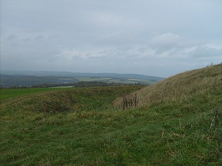
The Trundle is an Iron Age hillfort on St Roche's Hill about 4 miles (6 km) north of Chichester, West Sussex, England, built on the site of a causewayed enclosure, a form of early Neolithic earthwork found in northwestern Europe. Causewayed enclosures were built in England from shortly before 3700 BC until at least 3500 BC; they are characterized by the full or partial enclosure of an area with ditches that are interrupted by gaps, or causeways. Their purpose is not known; they may have been settlements, meeting places, or ritual sites. Hillforts were built as early as 1000 BC, in the Late Bronze Age, and continued to be built through the Iron Age until shortly before the Roman occupation. A chapel dedicated to St Roche was built on the hill around the end of the 14th century; it was in ruins by 1570. A windmill and a beacon were subsequently built on the hill. The site was occasionally used as a meeting place in the post-medieval period. The hillfort is still a substantial earthwork, but the Neolithic site was unknown until 1925 when archaeologist O.G.S. Crawford obtained an aerial photograph of the Trundle, clearly showing additional structures inside the ramparts of the hillfort. Causewayed enclosures were new to archaeology at the time, with only five known by 1930, and the photograph persuaded archaeologist E. Cecil Curwen to excavate the site in 1928 and 1930. These early digs established a construction date of about 500 BC to 100 BC for the hillfort and proved the existence of the Neolithic site. In 2011, the Gathering Time project published an analysis of radiocarbon dates from almost forty British causewayed enclosures, including some from the Trundle. The conclusion was that the Neolithic part of the site was probably constructed no earlier than the mid-fourth millennium BC. A review of the site in 1995 by Alastair Oswald noted the presence of fifteen possible Iron Age house platforms within the hillfort's ramparts.
Excerpt from the Wikipedia article The Trundle (License: CC BY-SA 3.0, Authors, Images).The Trundle
St Roche’s Hill, Chichester Lavant
Geographical coordinates (GPS) Address Nearby Places Show on map
Geographical coordinates (GPS)
| Latitude | Longitude |
|---|---|
| N 50.8925 ° | E -0.75388888888889 ° |
Address
St Roche’s Hill
PO18 0SP Chichester, Lavant
England, United Kingdom
Open on Google Maps


