place

Cowesett Pound

1742 establishments in Rhode IslandAgricultural buildings and structures on the National Register of Historic Places in Rhode IslandBuildings and structures in Warwick, Rhode IslandInfrastructure completed in 1742Kent County, Rhode Island Registered Historic Place stubs
National Register of Historic Places in Kent County, Rhode Island
WarwickRI CowesettPound

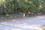
The Cowesett Pound is an historic animal pound on Cowesett Road in Warwick, Rhode Island. The pound, a roughly square structure built of unmortared fieldstone four to five feet in height, is estimated to have been built in 1742 by David Greene, although there was an older (probably wooden) pound already at the site. Its walls were probably once topped by capstones, but only one of these survives. The entrance to the pound has a wooden gate added during a 20th-century restoration.The pound was listed on the National Register of Historic Places in 1987.

Excerpt from the Wikipedia article Cowesett Pound (License: CC BY-SA 3.0, Authors, Images).

Cowesett Pound
Cowesett Road, Warwick

Geographical coordinates (GPS) Address Nearby Places
placeShow on map

Wikipedia: Cowesett PoundContinue reading on Wikipedia

Geographical coordinates (GPS)

Latitude Longitude
N 41.685555555556 ° E -71.462222222222 °
placeShow on map

Address

Cowesett Road 221
02886 Warwick
Rhode Island, United States
mapOpen on Google Maps

WarwickRI CowesettPound
Share experience

Nearby Places

Apponaug, Rhode Island

Apponaug is a neighborhood in central Warwick, Rhode Island, United States, situated on Apponaug Cove, a tributary to Greenwich Bay and nearby Narragansett Bay. The name Apponaug is a derivation of the Narragansett Indian word for "place of oysters". Indeed, Apponaug Cove holds one of the richest shellfish beds in the United States and was densely populated by the Narragansett people for many centuries prior to the arrival of European settlers. Apponaug consists of what is effectively a large rotary. In the 1960s, the Rhode Island Department of Transportation was in need of a faster way to feed the increasing number of cars through Apponaug that were en route to West Shore Road and other locations. Traffic patterns were rerouted in what was supposed to be a temporary solution, creating a one-way hub in the center of the village.Apponaug is located at the intersection of three of Warwick's primary streets: Post Road (U.S. Route 1), Greenwich Avenue (R.I. Route 5), and Centerville Road (R.I. Route 117). It is considered downtown or central Warwick, as Warwick City Hall is located here, plus police and fire headquarters, the Apponaug branch of the Warwick Public Library, a museum, and the post office. The cluster of municipal buildings in the center of Apponaug is designated as the Warwick Civic Center Historic District, while a cluster of stately homes in the southern part of the neighborhood is designated as the Apponaug Historic District.