place

Hope–Power–Cooke Streets Historic District

Geography of Providence, Rhode IslandHistoric districts in Providence County, Rhode IslandHistoric districts on the National Register of Historic Places in Rhode IslandNRHP infobox with nocatNational Register of Historic Places in Providence, Rhode Island
Providence, Rhode Island Registered Historic Place stubs
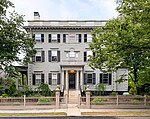
House at the corner of Manning and Hope Streets, Providence RI

The Hope–Power–Cooke Streets Historic District is a residential historic district on the East Side of Providence, Rhode Island. Located east of Brown University, the area is compact area developed in the mid-to-late 19th century as a residential district, with a cross-section of architectural styles from the early 19th to the early 20th century. The district is bounded on the north by Angell Street, on the east by Governor Street, on the south by Power Street, and on the west by Hope Street. Cooke Street is the main thorough fare running through the center of the district, which is six blocks long and two wide. The district abuts the Stimson Avenue Historic District, which lies immediately to its west.The district was listed on the National Register of Historic Places in 1973.

Excerpt from the Wikipedia article Hope–Power–Cooke Streets Historic District (License: CC BY-SA 3.0, Authors, Images).

Hope–Power–Cooke Streets Historic District
Hope Street, Providence

Geographical coordinates (GPS) Address Nearby Places
placeShow on map

Wikipedia: Hope–Power–Cooke Streets Historic DistrictContinue reading on Wikipedia

Geographical coordinates (GPS)

Latitude Longitude
N 41.826388888889 ° E -71.3975 °
placeShow on map

Address

Barus & Holley

Hope Street 184
02912 Providence
Rhode Island, United States
mapOpen on Google Maps

House at the corner of Manning and Hope Streets, Providence RI
Share experience

Nearby Places

Brown University Computing Laboratory

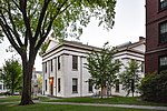
The Brown University Computing Laboratory is an academic building of Brown University located at 180 George Street in Providence, Rhode Island. It was built in 1961 and designed by noted architect Philip Johnson. The building was funded through a donation by the family of Thomas J. Watson, Sr. and dedicated to his memory. It was designed to house the IBM 7070 which was obtained through grants from the National Science Foundation and the IBM Corporation. On a wall in the main lobby hung a tapestry given by Philip Johnson after a design by Arshile Gorky.According to the Encyclopedia Brunoniana, Philip Johnson wrote, “I conceived the Brown Computing Laboratory as a porticus – a porch – to emphasize its importance as a technical center, its unique setting in the cityscape and its dignity as a memorial building. Though neo-Classical, therefore in conception, the materials and the design of the columns are quite contemporary. Only precast stone could have been used to form the X’s of the entablature; only plate glass could render the porch usable in New England. By use of the red granite chips, I thought to harmonize the Laboratory with the 19th century which surrounds it.” The machine room, a classroom, and meeting rooms were on the first floor and staff offices and storage rooms were in the basement. Also on the first floor was a dedicated space for a virtual reality environment known as the YURT.In 1988, the Applied Mathematics Division became the primary occupant after a new Center for Information Technology building was opened. Subsequently, the Center for Computation and Visualization became the primary occupant.