place

East Perth Power Station

Coal-fired power stations in Western AustraliaEast Perth, Western AustraliaEconomic history of Western AustraliaFormer power stations in AustraliaLandmarks in Perth, Western Australia
Oil-fired power stations in Western AustraliaState Register of Heritage Places in the City of VincentUse Australian English from July 2013
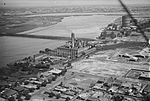
BunburyBridge East Perth c.1935

The East Perth Power Station is a disused power station in East Perth, Western Australia. For most of its life it was coal-fired, but ran on oil for six years. The site consists of a complex of industrial buildings occupying more than 8.5 hectares (21 acres), bounded by East Parade, Summers Street, the Swan River and the Graham Farmer Freeway.

Excerpt from the Wikipedia article East Perth Power Station (License: CC BY-SA 3.0, Authors, Images).

East Perth Power Station
Summers Street, City Of Vincent

Geographical coordinates (GPS) Address Nearby Places
placeShow on map

Wikipedia: East Perth Power StationContinue reading on Wikipedia

Geographical coordinates (GPS)

Latitude Longitude
N -31.94624 ° E 115.88047 °
placeShow on map

Address

Summers Street
6004 City Of Vincent, East Perth
Western Australia, Australia
mapOpen on Google Maps

BunburyBridge East Perth c.1935
Share experience

Nearby Places

Windan Bridge
Windan Bridge

The Windan Bridge is a six-lane road bridge in East Perth, Western Australia which crosses the Swan River and forms part of the Graham Farmer Freeway. Opened in 2000, it sits next to the Goongoongup railway bridge which was built in 1995. A joint venture between Transfield and Thiess Contractors was selected to construct the bridge from a short-list of three parties. Construction began in 1998. The incrementally-launched bridge is 403 m (1,322 ft) long with nine spans and comprises two prestressed concrete box girders on two rows of piers. A dual-use pedestrian/cycle pathway is located beneath the main deck. The bridge is named after Windan, a wife of Yellagonga (sometimes spelt Yallgunga), chief of the Mooro tribe. Her body was buried around the area, according to her wish. The name was chosen in consultation with Noongar elders as part of the Graham Farmer Freeway project. A naming ceremony was held on 9 April 2000 where a plaque was unveiled and a traditional Aboriginal smoking ceremony performed.The opening of the Graham Farmer Freeway and Windan Bridge was celebrated with a community open day on 22 April 2000 where the public could walk or cycle through the Graham Farmer tunnel and across the bridge. The freeway and bridge was open to traffic the following day.The bridge is part of a popular exercise trail known as the Windan Bridge Loop, which goes along the banks of the Swan River and across the Windan Bridge and The Causeway.