Temperanceville, Ontario

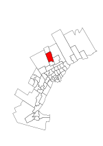
Temperanceville is an unincorporated community in the Regional Municipality of York in Ontario, Canada, straddling two geopolitical jurisdictions, King and Richmond Hill. It is located at the southeastern edge of King and northwestern part of Richmond Hill, east of King City and adjacent to the western part of Oak Ridges. The settlement became home to James and Mary Love in 1804, the former being a cobbler and farmer who was also a teetotaler.: 104 Their home would be used for church services, leading to the settlement being named 'Love's Corner'.: 104 The settlement also had an active temperance movement, with at least five temperance societies active in the area by the 1890s.: 104 Its name was changed in the early 1900s when the prohibition campaign became popular through the promotion of 'temperance values'. This campaign would later help cripple the hotel industry in the area. Temperanceville would grow to boast a post office, several businesses, and a market. Today, the most popular part of Temperanceville is the Temperanceville Park, which now has ample parking, a soccer field, and a large children's play area. In King Township, it is part of electoral Ward 1.
Excerpt from the Wikipedia article Temperanceville, Ontario (License: CC BY-SA 3.0, Authors, Images).Temperanceville, Ontario
King Road, Richmond Hill
Geographical coordinates (GPS) Address Nearby Places Show on map
Geographical coordinates (GPS)
| Latitude | Longitude |
|---|---|
| N 43.938888888889 ° | E -79.481388888889 ° |
Address
King Road 685
L4E 4W2 Richmond Hill
Ontario, Canada
Open on Google Maps


