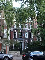
Chelsea Embankment

Chelsea Embankment is part of the Thames Embankment, a road and walkway along the north bank of the River Thames in central London, England. The western end of Chelsea Embankment, including a stretch of Cheyne Walk, is in the Royal Borough of Kensington and Chelsea; the eastern end, including Grosvenor Road and Millbank, is in the City of Westminster. Beneath the road lies the main low-level interceptor sewer taking waste water from west London eastwards towards Beckton. Chelsea Bridge and Albert Bridge are to the south. Royal Hospital Chelsea is to the north. Sloane Square is the closest tube station, located to the north.
Excerpt from the Wikipedia article Chelsea Embankment (License: CC BY-SA 3.0, Authors, Images).Chelsea Embankment
Chelsea Embankment, London Chelsea (Royal Borough of Kensington and Chelsea)
Geographical coordinates (GPS) Address Nearby Places Show on map
Geographical coordinates (GPS)
| Latitude | Longitude |
|---|---|
| N 51.484 ° | E -0.162 ° |
Address
Garden Corner
Chelsea Embankment 13
SW3 4LE London, Chelsea (Royal Borough of Kensington and Chelsea)
England, United Kingdom
Open on Google Maps


