place

Great Chishill

Former civil parishes in CambridgeshireHighest points of English countiesHills of CambridgeshireSouth Cambridgeshire DistrictUse British English from April 2018
Villages in Cambridgeshire
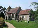
Great Chishill, St Swithuns geograph.org.uk 3304

Great Chishill is a village and former civil parish, now in the parish of Great and Little Chishill, in the South Cambridgeshire district, in the county of Cambridgeshire, England. The village is about 1 mile (1.6 km) east of the county boundary with Hertfordshire and about 4 miles (6 km) east of Royston. In 1961 the parish had a population of 293. The 2011 Census recorded Great and Little Chishill's population as 678.The parish was part of Essex until 1895, when the county boundary was revised. On 26 January 1929 the parish was renamed from "Great Chishall" to "Great Chishill". On 1 April 1968 the parish was abolished to form "Great and Little Chishill".The highest point of the current administrative county of Cambridgeshire, 146 m (479 ft) above sea level, is about 1⁄2 mile (800 m) east of St Swithun's parish church. However, as Great Chishill was historically a part of Essex (having been moved in boundary changes in 1895), the historic county top of Cambridgeshire is about 13 miles (21 km) to the east of Great Chishill close to the village of Castle Camps where a point on the disused RAF airfield reaches a height of 128 metres (420 ft) above sea level (grid reference TL 63282 41881). The highest point of Essex, Chrishall Common and the triple point of Cambridgeshire, Essex and Hertfordshire are near each other about 1.2 miles (2 km) south of Great Chishill.

Excerpt from the Wikipedia article Great Chishill (License: CC BY-SA 3.0, Authors, Images).

Great Chishill
Barley Road, South Cambridgeshire Great and Little Chishill

Geographical coordinates (GPS) Address Nearby Places
placeShow on map

Wikipedia: Great ChishillContinue reading on Wikipedia

Geographical coordinates (GPS)

Latitude Longitude
N 52.033 ° E 0.067 °
placeShow on map

Address

Barley Road

Barley Road
SG8 8SB South Cambridgeshire, Great and Little Chishill
England, United Kingdom
mapOpen on Google Maps

Great Chishill, St Swithuns geograph.org.uk 3304
Share experience

Nearby Places

Nuthampstead

Nuthampstead is a small village and civil parish in North East Hertfordshire located a few miles south of the town of Royston. In the 2001 census the parish had 139 residents, increasing to 142 at the 2011 Census.Nuthampstead was historically a hamlet in the parish of Barkway. The hamlet appointed its own overseer of the poor, and as such became an separate civil parish on 10 August 1866 under the Poor Law Amendment Act 1866. Despite becoming a separate civil parish, it remains part of the ecclesiastical parish of Barkway. Nuthampstead was included in the Royston Poor Law Union from 1835. It formed part of the Ashwell Rural District from 1894 until 1935, when that district was absorbed into the Hitchin Rural District. Since 1974, Nuthampstead has been part of North Hertfordshire. Due to its small size, Nuthampstead has a parish meeting rather than a parish council.During the Second World War, RAF Nuthampstead, situated next to the village, was home initially to the 55th Fighter Group and subsequently the 398th Bombardment Group of the U.S. Army Air Forces. This latter unit, the base's primary occupant, flew Boeing B-17 Flying Fortress heavy bombers on missions over occupied Europe.Known as USAAF Station 131 during the war, and less formally as AAF Nuthampstead, the airfield was constructed by U.S. Army engineer battalions starting in 1942. The site was formerly Scales Park, which was planted with oak trees after the Battle of Trafalgar. These were cleared to make room for the runways, hangars, and other wartime facilities. Visitors to the site will find that the main runways have since been removed, with a grass runway and service roads only remaining to allow the airfield to be used by light aircraft. In 1968–71 the Commission on the Third London Airport (the "Roskill Commission") considered Nuthampstead as one of its four short-listed sites, along with Cublington, Foulness (later known as Maplin Sands) and Thurleigh.Barkway VOR is located at Nuthampstead Airfield.Areas of the former airfield have been converted into a shooting ground. Since 1992, when planning permission was granted, the ground has developed to enable it to hold major championships in four international shooting disciplines.The village has a pub/restaurant with bed and breakfast facilities, called The Woodman Inn. Outside The Woodman Inn is a large memorial stone dedicated to the 398th squadron, and a museum of the airfield's history.