place

Shawell

Civil parishes in Harborough DistrictLeicestershire geography stubsUse British English from July 2015Villages in Leicestershire
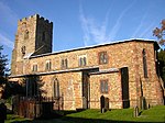
Shawell All Saints Church geograph.org.uk 1211457

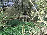
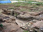
Shawell is a small village in the Harborough district of Leicestershire, England. Its population at the 2001 UK census was 126, increasing to 162 at the 2011 census. It lies less than a mile from the M1 and M6 motorways. The site of the Roman town of Tripontium is on the A5 (Watling Street), west of the village. Near to the church are the earthwork remains of a motte and bailey castle. The Great Central main railway line, the last main line to be built from the north of England to London, was opened on 15 March 1899 and ran just to the west of Shawell, mainly in a deep cutting where an important signal box was also sited. Although there was never a station at Shawell, one was proposed a little way to the south-west where the line crossed over the A5 and would have been named "Watling Street". The station, which would have lain roughly at the midpoint between Rugby and Lutterworth, was never built however, and the line closed on 5 May 1969, the cutting now being partly filled in.

Excerpt from the Wikipedia article Shawell (License: CC BY-SA 3.0, Authors, Images).

Shawell
Gibbet Lane, Harborough Shawell

Geographical coordinates (GPS) Address Nearby Places
placeShow on map

Wikipedia: ShawellContinue reading on Wikipedia

Geographical coordinates (GPS)

Latitude Longitude
N 52.41799 ° E -1.20008 °
placeShow on map

Address

Gibbet Lane

Gibbet Lane
LE17 6AB Harborough, Shawell
England, United Kingdom
mapOpen on Google Maps

Shawell All Saints Church geograph.org.uk 1211457
Share experience

Nearby Places

Catthorpe
Catthorpe

Catthorpe is a village and civil parish in the Harborough district of Leicestershire, England. It is located beside the River Avon and close to the A5 road, and hence close to the tripoint at Dow Bridge formed by Leicestershire, Northamptonshire and Warwickshire; the nearest towns are Rugby, in Warwickshire around 4 miles (6.4 km) to the southwest, and Lutterworth around 4 miles (6.4 km) to the north. At the 2001 Census, the parish had a population of 179, falling slightly to 173 at the 2011 census, further decreasing to 156 at the 2021 census.The name 'Catthorpe' is made up of 'thorpe' meaning 'outlying farm/settlement' and 'Cat'. 'Cat' was probably added after Isabel le Cat and Simon Mallore donated the land to Leicester Abbey.Catthorpe gives its name to the nearby Catthorpe Interchange road junction formed by the M1 and M6 motorways and the A14 road, which was known to be regularly congested owing to its non-standard design. The A14 passed under both motorways; these underpasses were built in the 1960s for the former A427, which passed through Catthorpe. Between 2014 and 2016 the interchange was the subject of a major redesign to reduce the congestion and improve safety by providing free-flowing links and removing direct access from the local road network.Between 1850 and 1966 Catthorpe was served by the nearby Lilbourne railway station on the now dismantled Rugby to Peterborough Line Catthorpe briefly came to national attention in 1999 when the Latvian alleged war criminal Konrāds Kalējs was revealed to be living at Catthorpe Manor, a nursing home near the village. The parish church, dedicated to St Thomas, dates from the 14th century and is Grade II* listed, but is currently on Historic England's Heritage at Risk Register as being in a 'vary bad' state due to masonry defects and heritage crime. There is a village pub called the Cherry Tree and farm shop and restaurant, both are located on Main Street.

Newton, Warwickshire

Newton is a small village in the civil parish of Newton and Biggin in the Rugby borough of Warwickshire, England. The civil parish population taken at the 2021 census was 1,273.Newton is about 3 miles (5 km) north east of Rugby, and is close to the A5 road which marks the border with Leicestershire and Northamptonshire, the three counties meet at Dow Bridge east of the village, where the A5 crosses the River Avon. Just north of the village are the remains of the Roman town of Tripontium. The village is also at the northern end of the "Great Central Walk" the footpath along the trackbed of the old Great Central Main Line. The main industry in the area is gravel extraction, which continues near the A5. Most of the houses in the village are of modern construction and were built to house workers for this industry. The Stag and Pheasant pub in Main St whilst not being the oldest pub in Warwickshire is the oldest building used as a pub in the county. Although the thatched building has a brick facing, probably added in the 17th century, its core is a massive oak cruck frame of indeterminate age, possibly Saxon. The Townlands Allotments are also of some antiquity being established in 1752 at the time of the enclosures. They are at the end of Little London Lane - one of a number of localities carrying this name in England. The origins of the name are not believed to be directly linked with "London" but rather a corruption of the Old English "utlenden". Utlenden (outsiders) were Welsh drovers who set up camps on waste land en route to markets in London. Edward Cave, the 18th century publisher of the world's first magazine was born in the village in 1691. The parish of Newton and Biggin includes the deserted medieval settlement of Biggin to the south-east of Newton village. Biggin Mill, a former water mill, existed 440 yards (400 m) south-east of the village; its remains still exist.