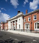
Denmark Hill

Denmark Hill is an area and road in Camberwell, in the London Borough of Southwark. It is a sub-section of the western flank of the Norwood Ridge, centred on the long, curved Ruskin Park slope of the ridge. The area and road is said to have acquired its name from Queen Anne's husband, Prince George of Denmark, who hunted there.It is part of the A215 which north of its main foot, Camberwell Green, becomes Camberwell Road and south of Red Post Hill becomes named Herne Hill, another district. Its postcode is SE5. North-east and south-easterly slopes of the same eminence are named Grove Hill and Dog Kennel Hill, on top of which the summit is shared with Champion Hill, the only divide being proximity to the respective two affluent streets which intersection on Camberwell descent. From Camberwell Green northwards the land is much lower and very gently sloped as in northern Brixton at its other foot, in the west. There are good views across central London from vantage points (e.g. top-storey windows). On a clear day some viewers can read the time on the Big Ben clockface.
Excerpt from the Wikipedia article Denmark Hill (License: CC BY-SA 3.0, Authors, Images).Denmark Hill
Champion Park, London Camberwell (London Borough of Southwark)
Geographical coordinates (GPS) Address Nearby Places Show on map
Geographical coordinates (GPS)
| Latitude | Longitude |
|---|---|
| N 51.4678 ° | E -0.0902 ° |
Address
Denmark Hill
Champion Park
SE5 8BB London, Camberwell (London Borough of Southwark)
England, United Kingdom
Open on Google Maps


