place

Minneapolis Saint Paul Rochester & Dubuque Electric Traction Company Depot
Buildings and structures in Dakota County, MinnesotaBurnsville, MinnesotaFormer railway stations in MinnesotaNational Register of Historic Places in Dakota County, MinnesotaRailway stations in the United States opened in 1910
Railway stations on the National Register of Historic Places in Minnesota
Orchard Gardens Depot

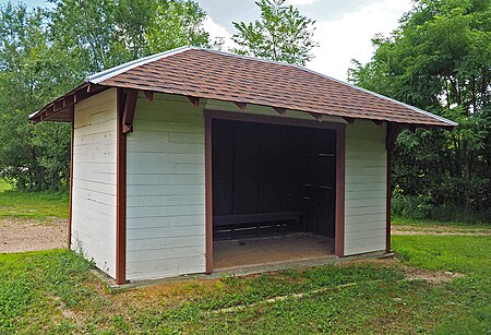
The Minneapolis Saint Paul Rochester & Dubuque Electric Traction Company Depot or Orchard Gardens Railway Station, located at County Road 5 and 155th Street in Burnsville in the U.S. state of Minnesota was built in 1910 on the Dan Patch Line, later known as the Minneapolis, Northfield and Southern Railway. Connecting Northfield and Minneapolis, the line carried agricultural produce from rural Dakota County to urban markets. When Orchard Gardens in Burnsville was platted in 1910, this small depot was added for the area's passengers. Orchard Gardens farmers grew onions, apples, and flowers, and produced eggs and milk until the Great Depression caused locals to find employment in Minneapolis. Then the station attracted more commuters than farmers.

Excerpt from the Wikipedia article Minneapolis Saint Paul Rochester & Dubuque Electric Traction Company Depot (License: CC BY-SA 3.0, Authors, Images).

Minneapolis Saint Paul Rochester & Dubuque Electric Traction Company Depot
155th Street West,

Geographical coordinates (GPS) Address Nearby Places
placeShow on map

Wikipedia: Minneapolis Saint Paul Rochester & Dubuque Electric Traction Company DepotContinue reading on Wikipedia

Geographical coordinates (GPS)

Latitude Longitude
N 44.72275 ° E -93.298444444444 °
placeShow on map

Address

155th Street West 1599
55306
Minnesota, United States
mapOpen on Google Maps

Orchard Gardens Depot
Share experience

Nearby Places

Burnsville, Minnesota

Burnsville ( BURNZ-vil) is a city 15 miles (24 km) south of downtown Minneapolis in Dakota County, Minnesota. The city is situated on a bluff overlooking the south bank of the Minnesota River, upstream from its confluence with the Mississippi River. Burnsville and nearby suburbs form the southern portion of Minneapolis–Saint Paul, the 16th-largest metropolitan area in the United States, with about 3.7 million residents. At the 2020 census the population was 64,317.Burnsville is home to a regional mall (Burnsville Center), a section of Murphy-Hanrehan Park Reserve, 310-foot (94 m) vertical ski peak Buck Hill, and part of the Minnesota Valley National Wildlife Refuge. Burnsville stands on land that once contained a village of Mdewakanton Dakota. Later, it became a rural Irish farming community. Burnsville became Minnesota's 14th-largest city in the 2020 census following the construction of Interstate 35. Now the ninth-largest suburb in the metro area and a bedroom community of both Minneapolis and Saint Paul, it was fully built by the late 2000s. Burnsville's downtown area is called Heart of the City with urban-style retail and condominiums. The Burnsville Transit Station serves as the hub and headquarters of the Minnesota Valley Transit Authority, providing regional bus service to five other suburbs. The name Burnsville is attributed to an early Irish settler and land owner, William Byrne. His surname was recorded as "Burns" and was never corrected.