place

Dorrington, Lincolnshire

Civil parishes in LincolnshireNorth Kesteven DistrictUse British English from October 2014Villages in Lincolnshire
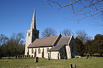
Dorrington church geograph.org.uk 1744723

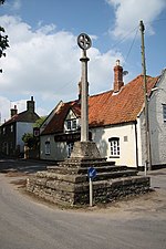
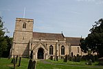
Dorrington is a village and civil parish in the North Kesteven district of Lincolnshire, England. It is situated 1.2 miles (2 km) both south from Digby and north from Ruskington. It is to the east of the north–south B1188, which lies just within the parish boundaries. The nearest town is Sleaford, approximately 4 miles (6 km) to the south. In the 2001 census, the parish had a population of 340, increasing slightly to 344 at the 2011 census.Dorrington Grade I listed Anglican church is dedicated to St James and St John. It is mainly in Decorated style. On the sides of the east window are ogee canopied niches. The church tower previously held a spire. On the exterior of the east window is a sculpture of the Last Judgment. The church is situated on the B1188 approximately 0.5 miles (0.8 km) north-west from the village centre, overlooking the village. Frank Whittle lodged at a house in the village while developing the jet engine at RAF Cranwell; the remains of this house lie near the church. In the village are the remains of a Grade II listed Medieval ashlar cross.The Peterborough to Lincoln Line passes to the east of the village. The village public house is the Musicians Arms on Main Street.

Excerpt from the Wikipedia article Dorrington, Lincolnshire (License: CC BY-SA 3.0, Authors, Images).

Dorrington, Lincolnshire
Main Street, North Kesteven Dorrington

Geographical coordinates (GPS) Address Nearby Places
placeShow on map

Wikipedia: Dorrington, LincolnshireContinue reading on Wikipedia

Geographical coordinates (GPS)

Latitude Longitude
N 53.062 ° E -0.389 °
placeShow on map

Address

Main Street

Main Street
LN4 3PX North Kesteven, Dorrington
England, United Kingdom
mapOpen on Google Maps

Dorrington church geograph.org.uk 1744723
Share experience

Nearby Places

Leasingham
Leasingham

Leasingham is a village and civil parish in the North Kesteven district of Lincolnshire, England. It is situated less than 2 miles (3 km) north from Sleaford, and just off the A15. The hamlet of Roxholm lies to the north. When combined with Rauceby figures, there are a total of 916 households as of 2011. The population of the civil parish at the 2011 census was 1,584.The B1209 passes through the village to join the A153 further east, passing across Leasingham Moor. Close by to the west is RAF Cranwell. The A15 used to run through the village on Captain's Hill until the 1950s. Captain's Hill takes its name from the local landowner, Captain Richard Wharton-Myddleton, who had been an ensign at the battle of Waterloo. He lived in Leasingham Hall (built about 1836) now a Grade II listed house. On 4 January 2022, this hall had a renovation to transform it into 6 flats, however work could not begin initially due to safety concerns over tree preservation. Other buildings in the village include the church of St Andrews, a Wesleyan chapel, manor house, village hall and a row of alms houses. The local school is St Andrew's C.E. Primary School, which partners with Carre's Grammar School using its Outreach programme. The playing fields include a bowls club and cricket pitch. Amenities include the Duke of Wellington public house, Busy Bees Preschool, a post office shop, corner shop, farm shop, and two hairdressers. A local bus service runs every hour to Sleaford, with links to Lincoln, Grantham, Nottingham and Skegness.