place

Shipley, West Sussex

Horsham DistrictVillages in West Sussex
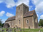
Shipley, West Sussex church from windmill

Shipley is a village and civil parish in the Horsham District of West Sussex, England. It lies just off the A272 road 6 miles (10 kilometres) north-east of Storrington. The parish includes the village of Coolham and the hamlets of Dragon's Green, Brooks Green and Broomer's Corner. Shipley is first mentioned in a charter of 1073 as Scapeleia, and in the Domesday Book of 1086 as Sepelei. The name derives from the Old English scēap ('sheep') and lēah ('open ground, such as meadow, pasture, or arable land'). Thus it means 'sheep-clearing' or 'sheep-pasture'.The western River Adur flows through the village, where it meets a significant tributary, Lancing Brook. The parish has a land area of 3,125 hectares (7,720 acres). In the 2001 census 1075 people lived in 448 households of whom 596 were economically active. At the 2011 Census the population included the hamlet of Coolham and increased to a total of 1,147.Shipley was home to Hilaire Belloc who in 1906 purchased Kings Land, with a house, 5 acres (2 ha) and Shipley Windmill, which was used in the television series Jonathan Creek as Creek's residence.The churchyard of St. Mary the Virgin is the burial place of composer John Ireland (1879–1962).

Excerpt from the Wikipedia article Shipley, West Sussex (License: CC BY-SA 3.0, Authors, Images).

Shipley, West Sussex
Red Lane,

Geographical coordinates (GPS) Address Nearby Places
placeShow on map

Wikipedia: Shipley, West SussexContinue reading on Wikipedia

Geographical coordinates (GPS)

Latitude Longitude
N 50.98539 ° E -0.37078 °
placeShow on map

Address

Red Lane
RH13 8PH
England, United Kingdom
mapOpen on Google Maps

Shipley, West Sussex church from windmill
Share experience

Nearby Places

Brightling Park
Brightling Park

Brightling Park (previously known as Rose Hill) is a country estate which lies in the parishes of Brightling and Dallington in the Rother district of East Sussex, England. It is now the home of Grissell Racing, who have operated a racehorse training facility there for more than 30 years.The 18th-century house is brick-built in two storeys with a nine window north front and stands in some 200ha (490 acres) of parkland. Additional wings added in 1810 were demolished in 1955. 18th-century grade II listed stables and a coach-house to the south-east of the house comprise a single long building. The house is approached by an avenue bounded by ha-has, to the side of which stands a grade II listed alcove or summerhouse. The parkland is Grade II listed whereas Brightling Park House itself is a Grade II* listed building.Associated with the estate are a number of follies and an observatory, all designed by architect Sir Robert Smirke for John "Mad Jack" Fuller in the early 1800s. The Alcove or Summerhouse stands to the west of the house within the park and is a semicircular alcove built of red brick with a four-centred archway entrance flanked by pairs of interlocking columns. Built in 1803, it is a Grade II listed building.The Temple, standing within the park 400m to the south-west of the house, is a small circular building consisting of a colonnade surmounted by a dome. It is a Grade II* listed building.The Obelisk, also known as Brightling Needle, stands some 500m outside the park's perimeter wall on top of Brightling Down and is a Grade II* listed building.The Observatory was built in 1818 on a high spot outside the park some 150m to the west. It is a T-shaped one storey building built of ashlar with slits for the telescopes. Now a private house, it is also a Grade II* listed building.

Coolham
Coolham

Coolham is a small village in the civil parish of Shipley and the Horsham District of West Sussex, England. It is located at the crossroads of the A272 and B2139 roads 2.8 miles (4.6 km) southeast of Billingshurst. At the crossroads is an old timber-framed inn, the Selsey Arms, formerly the Duke's Head, and before that The King of Prussia.During the Second World War there was an Advanced Landing Ground nearby called RAF Coolham, used to support the D-Day landings. This was only in use for about eighteen months, and had almost no permanent buildings. The airmen lived under canvas. Both Polish and British airmen were stationed there, and there is a monument outside the Selsey Arms that lists the names of those who died. The land has long since been reclaimed for agricultural purposes, but there is still a footpath around the field, with trees planted at intervals to commemorate the dead airmen. Each tree has a name plaque attached.There was once a prominent Quaker community in Coolham, and the "Blue Idol" meeting house, a timber-framed building, still exists. William Penn, who earlier had founded Pennsylvania in America, was closely involved in its establishment, and is believed to have worshipped there. The local junior school was founded as the Coolham British School (later Coolham Primary School) in 1889 by the Quakers. In the mid-twentieth century it moved to its present site, where it is known as the William Penn Primary School.Coolham is in the ancient parish of Shipley, which adjoins the A24, near the ruin of Knepp Castle. The castle dates back to medieval times, and was used as a hunting lodge for King John. The site of the parish church of St Mary the Virgin, Shipley, dates back to the Knights Templar, and close by is Shipley Windmill, which was once owned by the Sussex writer Hilaire Belloc during the first half of the twentieth century. The windmill was featured as the home of Jonathan Creek in a TV series that ran on UK television from the late 1990s.