place

Martha's Vineyard AVA
1985 establishments in MassachusettsAmerican Viticultural AreasGeography of Dukes County, MassachusettsGeography of Martha's VineyardMassachusetts geography stubs
Massachusetts wineUse mdy dates from April 2021Wine region stubs
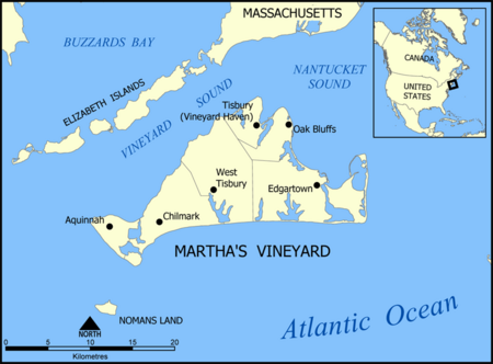
Martha's Vineyard map

The Martha's Vineyard AVA is an American Viticultural Area located in Dukes County, Massachusetts, including all of the land on the islands named Martha's Vineyard and Chappaquiddick Island. These two islands are located off the southern Massachusetts coast, surrounded by Vineyard Sound, Nantucket Sound, and the Atlantic Ocean. The creation of the AVA in 1985 was controversial. Objections were lodged by the proprietors of a vineyard in California also named Martha's Vineyard, who felt that the creation of an AVA with the same name would dilute their brand value. Federal regulators ruled in favor of the AVA, citing historical evidence that viticulture has been practiced on the Massachusetts island named Martha's Vineyard since at least 1602. The maritime location helps to create a slightly warmer climate than the nearby coastal regions of Massachusetts, and a growing season that is almost three weeks longer. The hardiness zone is 7a.

Excerpt from the Wikipedia article Martha's Vineyard AVA (License: CC BY-SA 3.0, Authors, Images).

Martha's Vineyard AVA
Fire Road C,

Geographical coordinates (GPS) Address Nearby Places
placeShow on map

Wikipedia: Martha's Vineyard AVAContinue reading on Wikipedia

Geographical coordinates (GPS)

Latitude Longitude
N 41.4 ° E -70.616666666667 °
placeShow on map

Address

Fire Road C

Fire Road C
02575
Massachusetts, United States
mapOpen on Google Maps

Martha's Vineyard map
Share experience

Nearby Places

Martha's Vineyard
Martha's Vineyard

Martha's Vineyard, often simply called the Vineyard, is an island in the Northeastern United States, south of Cape Cod in Dukes County, Massachusetts, known for being a popular, affluent summer colony. Martha's Vineyard includes the smaller adjacent Chappaquiddick Island, a peninsula, currently connected to the Vineyard. It is the 58th largest island in the U.S., with a land area of about 96 square miles (250 km2), and the third-largest on the East Coast, after Long Island and Mount Desert Island. Martha's Vineyard constitutes the bulk of Dukes County, which also includes the Elizabeth Islands and the island of Nomans Land. The island's year-round population has considerably increased since the 1960s. In the 2023 Martha’s Vineyard Commission report, the year-round population was 20,530, an increase from 16,460 in 2010. The summer population swells to more than 200,000 people. About 56 percent of the Vineyard's 14,621 homes are seasonally occupied.A study by the Martha's Vineyard Commission found that the cost of living on the island is 60 percent higher than the national average, and housing prices are 96 percent higher. A study of housing needs by the Commission found that the average weekly wage on Martha's Vineyard was "71 percent of the state average, the median home price was 54 percent above the state's and the median rent exceeded the state's by 17 percent," all leading to a stark example of severe income inequalities between year-round residents and their seasonal counterparts.