Broughton, Northamptonshire

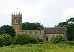
Broughton is a large village and civil parish in North Northamptonshire, England. The village is around 2 miles (3.2 km) south-west of Kettering and is bypassed by the A43 road. At the 2011 census, the population of the parish was 2,208.The village's name is derived from Old English meaning "fortification farm/settlement" or, perhaps, "brook farm/settlement".Broughton appears in the Domesday Book of 1086 as Burtone. The church (St. Andrew), which is mostly early 14th century (although the chancel was actually rebuilt in 1828), incorporates part of a (12th century) Norman aisleless church at the south-west angle, including the reset south doorway with colonettes, scallop capitals and zigzags. The village has some notable Jacobean houses.Broughton currently has one pub, The Red Lion; it used to also have The Sun but that closed. A protest to keep the pub running was fought for by driving a tank to Kettering Borough Council offices but no appeal has been won. The village also has three shops. It used to have a separate post office; that is now part of one of the shops. Many years ago, it had a cinema, five bakers, 7 pubs, 6 shops, a petrol station, and a butcher.
Excerpt from the Wikipedia article Broughton, Northamptonshire (License: CC BY-SA 3.0, Authors, Images).Broughton, Northamptonshire
Wellingborough Road,
Geographical coordinates (GPS) Address Nearby Places Show on map
Geographical coordinates (GPS)
| Latitude | Longitude |
|---|---|
| N 52.3712 ° | E -0.775 ° |
Address
Wellingborough Road
Wellingborough Road
NN14 1NR , Broughton
England, United Kingdom
Open on Google Maps


