Turners Hill
Mid Sussex DistrictVillages in West Sussex

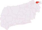
Turners Hill is a village and civil parish in the Mid Sussex District of West Sussex, England. The civil parish covers an area of 1,390 hectares (3,400 acres), and has a population of 1,849 (2001 census) increasing to 1,919 at the 2011 Census. The village is located three miles (5 km) south-west of East Grinstead, four miles (6 km) to the south-east of Crawley and stands on a steep ridge line at one of the highest points (580 feet above sea level) of the High Weald, where two historically important routes, the B2110 and B2028, cross.
Excerpt from the Wikipedia article Turners Hill (License: CC BY-SA 3.0, Authors, Images).Turners Hill
North Street, Mid Sussex
Geographical coordinates (GPS) Address Nearby Places Show on map
Geographical coordinates (GPS)
| Latitude | Longitude |
|---|---|
| N 51.10368 ° | E -0.08519 ° |
Address
North Street
North Street
RH10 4NT Mid Sussex
England, United Kingdom
Open on Google Maps


