Temple Bruer Preceptory

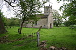
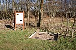
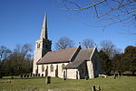
Temple Bruer Preceptory is a historic building in the civil parish of Temple Bruer with Temple High Grange, North Kesteven, Lincolnshire, England. It is one of the few Knights Templar sites left in England where any ruins remain standing. Its name comes from its Templar ownership and its position in the middle of the Lincoln Heath, bruyère (heather) from the French language current at the time. It was founded in the period 1150 to 1160 and the order was dissolved in 1312. The site is located between the A15 and A607 roads, 2.5 miles (4.0 km) north from Cranwell. The site has been excavated twice, firstly by the Rev Dr. G. Oliver, the rector of Scopwick in 1832–3, and in 1908 by Sir William St John Hope.
Excerpt from the Wikipedia article Temple Bruer Preceptory (License: CC BY-SA 3.0, Authors, Images).Temple Bruer Preceptory
Temple Road, North Kesteven Temple Bruer with Temple High Grange
Geographical coordinates (GPS) Address External links Nearby Places Show on map
Geographical coordinates (GPS)
| Latitude | Longitude |
|---|---|
| N 53.0711 ° | E -0.4962 ° |
Address
Temple Bruer Preceptory
Temple Road
LN5 0QQ North Kesteven, Temple Bruer with Temple High Grange
England, United Kingdom
Open on Google Maps
