Totterdown
Areas of BristolPlaces formerly in Somerset

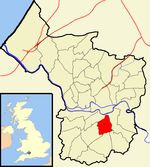
Totterdown is an inner-suburb of Bristol, England, situated just south of the River Avon and to the south-east of Temple Meads railway station and the city centre. It rises relatively steeply from the river bank to a largely terraced Victorian housing area which is notable for its painted homes - often in bright colours - that can be seen from some distance. There is a tight network of extremely steep roads in Upper Totterdown, of which Vale Street, although very short, is alleged to be the steepest residential road in England.
Excerpt from the Wikipedia article Totterdown (License: CC BY-SA 3.0, Authors, Images).Totterdown
Copse Road, Bristol St Philip's Marsh
Geographical coordinates (GPS) Address Nearby Places Show on map
Geographical coordinates (GPS)
| Latitude | Longitude |
|---|---|
| N 51.4388 ° | E -2.566 ° |
Address
Copse Road 10
BS4 2HZ Bristol, St Philip's Marsh
England, United Kingdom
Open on Google Maps


