La Roquette-sur-Var
Alpes-Maritimes geography stubsCommunes of Alpes-MaritimesPages with French IPA

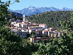
La Roquette-sur-Var (French pronunciation: [la ʁɔkɛt syʁ vaʁ], literally La Roquette on Var; Occitan: Sa Roqueta de Var; Italian: Rocchetta di Varo) is a commune in the Alpes-Maritimes department in southeastern France. It is one of sixteen villages grouped together by the Métropole Nice Côte d'Azur tourist department as the Route des Villages Perchés (Route of Perched Villages). The others are: Aspremont, Carros, Castagniers, Coaraze, Colomars, Duranus, Èze, Falicon, La Gaude, Lantosque, Levens, Saint-Blaise, Saint-Jeannet, Tourrette-Levens and Utelle.
Excerpt from the Wikipedia article La Roquette-sur-Var (License: CC BY-SA 3.0, Authors, Images).La Roquette-sur-Var
route des amandiers, Nice
Geographical coordinates (GPS) Address Nearby Places Show on map
Geographical coordinates (GPS)
| Latitude | Longitude |
|---|---|
| N 43.8292 ° | E 7.1997 ° |
Address
route des amandiers
route des amandiers
06670 Nice
Provence-Alpes-Côte d'Azur, France
Open on Google Maps


