Chelmer and Blackwater Navigation

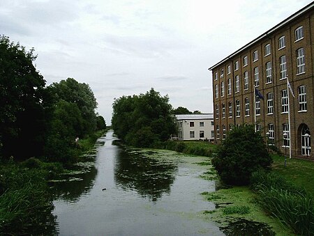
The Chelmer and Blackwater Navigation is the canalisation of the Rivers Chelmer and Blackwater in Essex, in the east of England. The navigation runs for 13.75 miles (22.13 km) from Springfield Basin in Chelmsford to the sea lock at Heybridge Basin near Maldon. Initial plans faced spirited opposition from Maldon, which were overcome by avoiding the town and terminating at Heybridge, and the navigation opened in 1797. There were some teething problems, and the engineer John Rennie was called back on two occasions to recommend improvements. The impact of the railways was less severe than on many canals, as there was never a direct line between Chelmsford and Maldon. The sea lock at Heybridge was enlarged after the Second World War, but trade gradually declined and ceased in 1972. Unlike most canals, it was not nationalised in 1948, and remained under the control of the original company. The first leisure boats to use the navigation did so in 1973, when the Inland Waterways Association organised a rally at Chelmsford. Springfield Basin was restored in 1992, but the proprietors faced bankruptcy in 2003, and after two years of negotiation, Essex Waterways Ltd, a wholly owned subsidiary of the Inland Waterways Association, took over responsibility for management, although the proprietors retained ownership. Because Essex and Suffolk Water abstract water from the navigation to supply Hanningfield Reservoir, they have a statutory obligation to maintain the outer gates at Heybridge sea lock, to prevent salt water entering the drinking water supply. They undertook major refurbishment work at the lock during the winters of 2016/17 and 2017/18, including replacement of the outer sea gate with a new design. A long-standing ambition, first proposed in 1985, has been to provide a better destination at Chelmsford, by providing access for boats to the town centre. A proposed link from Springfield Basin has been thwarted by road building in the area, but a plan to replace the automatic weir below Chelmsford Town Centre with a new structure incorporating a navigation lock was recommended in 2020.
Excerpt from the Wikipedia article Chelmer and Blackwater Navigation (License: CC BY-SA 3.0, Authors, Images).Chelmer and Blackwater Navigation
FP33, Essex
Geographical coordinates (GPS) Address Nearby Places Show on map
Geographical coordinates (GPS)
| Latitude | Longitude |
|---|---|
| N 51.75395 ° | E 0.59433 ° |
Address
FP33
FP33
CM9 6QU Essex, Woodham Walter
England, United Kingdom
Open on Google Maps


