Stanford Rivers

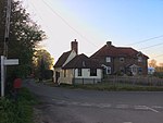
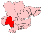
Stanford Rivers is a village and civil parish in the Epping Forest district of Essex, England. The parish, which is approximately 11 miles (18 km) west from the county town of Chelmsford, contains the village of Toot Hill and the hamlet of Little End, both settlements larger than Stanford Rivers village, and the hamlet of Clatterford End. The village is 2.0 miles (3 km) south-east of Chipping Ongar, 3 miles (5 km) south-west of North Weald Bassett and 3 miles north-west of Kelvedon Hatch. The parish covers an area of 1,749 hectares. The nearest London Underground station to the village is Epping, 5 miles (8 km) to the west, the terminus of the Central line. Harlow Town Station, a National Rail station operated by Greater Anglia, is 8 miles (13 km) to the northwest.
Excerpt from the Wikipedia article Stanford Rivers (License: CC BY-SA 3.0, Authors, Images).Stanford Rivers
School Road, Epping Forest Stanford Rivers
Geographical coordinates (GPS) Address Nearby Places Show on map
Geographical coordinates (GPS)
| Latitude | Longitude |
|---|---|
| N 51.689528 ° | E 0.207539 ° |
Address
School Road
School Road
CM5 9PU Epping Forest, Stanford Rivers
England, United Kingdom
Open on Google Maps


