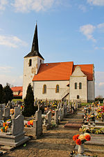
Jabłonów, Lower Silesian Voivodeship
Polkowice County geography stubsVillages in Polkowice County
Jabłonów [jaˈbwɔnuf] is a village in the administrative district of Gmina Chocianów, within Polkowice County, Lower Silesian Voivodeship, in south-western Poland. Prior to 1945 it was in Germany. It lies approximately 10 kilometres (6 mi) north of Chocianów, 11 kilometres (7 mi) west of Polkowice, and 89 kilometres (55 mi) north-west of the regional capital Wrocław.
Excerpt from the Wikipedia article Jabłonów, Lower Silesian Voivodeship (License: CC BY-SA 3.0, Authors).Jabłonów, Lower Silesian Voivodeship
gmina Chocianów
Geographical coordinates (GPS) Address Nearby Places Show on map
Geographical coordinates (GPS)
| Latitude | Longitude |
|---|---|
| N 51.504166666667 ° | E 15.916111111111 ° |
Address
12
59-140 gmina Chocianów
Lower Silesian Voivodeship, Poland
Open on Google Maps


