place

Northenden

Areas of ManchesterManchester City Council WardsPlaces of local interest needing cleanupWythenshawe
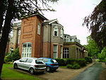
Palatine Road, Northenden geograph.org.uk 357179

Northenden is a suburb of Manchester, Greater Manchester, England, with a population of 14,771 at the 2011 census. It lies on the south side of the River Mersey, 4.2 miles (6.8 km) west of Stockport and 5.2 miles (8.4 km) south of Manchester city centre, bounded by Didsbury to the north, Gatley to the east, Sale to the west and Wythenshawe to the south. Historically a rural township and parish within the hundred of Bucklow in Cheshire, despite unplanned urbanisation and population growth in its neighbours in the 19th century, Northenden remained a comparatively rural and unpopulated area which spanned the hamlets of Lawton Moor, Northern Moor, Rose Hill and a part of what is now Wythenshawe. By 1866 Northenden had coalesced and became a civil parish. The industrialisation of neighbouring Manchester resulted in overpopulation in the early 20th century. Manchester City Council used the Local Government Act 1929 to extend its boundaries to encompass Northenden in 1931 and throughout the mid-20th century it was redeveloped as an overspill estate.

Excerpt from the Wikipedia article Northenden (License: CC BY-SA 3.0, Authors, Images).

Northenden
Palatine Road, Manchester Northenden

Geographical coordinates (GPS) Address Nearby Places
placeShow on map

Wikipedia: NorthendenContinue reading on Wikipedia

Geographical coordinates (GPS)

Latitude Longitude
N 53.4075 ° E -2.258333 °
placeShow on map

Address

Palatine Road
M22 4FZ Manchester, Northenden
England, United Kingdom
mapOpen on Google Maps

Palatine Road, Northenden geograph.org.uk 357179
Share experience

Nearby Places

Wythenshawe Bus Garage

Wythenshawe Bus Garage is a Grade II* listed building in Wythenshawe, Greater Manchester, England.Designed by Manchester City Architects Department under G. Noel Hill, and completed in 1942, the garage was a pioneering example of its type of construction. It is located in Harling Road, off Sharston Road in the Sharston district of Wythenshawe. It was the second-largest reinforced concrete shell roof structure to be constructed in England. The building’s structure was particularly innovative for its time. Its concrete arches have a span of 165 ft (50.3m) from side to side, are 42 ft (12.8m) high and spaced 42 ft (12.8m) apart. The tensile concrete shell roof between these concrete arches is just 2.5 inches (63.5mm) thick and is daringly punctured by large rooflights. Wythenshawe Garage proved to be the model for much larger buildings using the concrete shell roof structure technique, which was an economic method of achieving large uninterrupted roof spans. Originally designed to garage 100 double-decker buses, the building on its completion was immediately commandeered by the Ministry of Aircraft Production for work associated with the building and repair of Avro Lancaster bombers in support of Britain’s Second World War efforts.On its return to Manchester Corporation use in 1946, the building was known as Northenden garage. It housed buses used mainly on routes linking the city centre and the large Wythenshawe housing estate, also on three serving Gatley and Styal, the Sale Moor and Brooklands districts of Sale, and Baguley and the Timperley district of Altrincham. The building is now in private ownership and is used for car parking.

Northern Moor
Northern Moor

Northern Moor is an area of Manchester, England, north of Baguley, west of Northenden and east of Sale, 5 miles south of Manchester city centre. The Tatton family lived from 1540 to 1926 at Wythenshawe Hall in Northern Moor; land around it is now Wythenshawe Park, which was a deer park from 1200 to 1540. In former centuries it was spelt "Northen Moor" and meant "the moor area belonging to Northenden". Until 1931, Northern Moor was part of Cheshire, before Manchester expanded south of the River Mersey and its borders were changed to include Northern Moor and Northenden. The area includes Lawton Moor, and the northern border is now with Sale Moor. The area has grown since the 1930s and 1940s to cover the area of the old Tatton family estate and farms. In 1926, Mr.Tatton (country squire at Wythenshawe Hall) sold land in Wythenshawe, and it came into the hands of Manchester Corporation, which chose four farm fields in Northern Moor to be the Manchester (Wythenshawe) Aerodrome. Its runway opened in early 1929, with the old farm house used for offices. The airfield closed a few years later, moved to Eccles and became Barton Airport. The land was redeveloped with Rackhouse School opening in 1935, St. Michael's Church in 1937, St Aidan's Catholic School in 1938, and houses built in the 1930s and 1940s on the land. Northern Moor has grown further since, expanding to the Sale border. The Kerscott estate was a fruit farm with apple and plum trees. The area is now part of the Wythenshawe and Sale East Parliament constituency.