Lühesand
ElbeIslands of Lower SaxonyLower Saxony geography stubsRiver islands of GermanyStade (district)

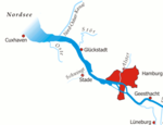
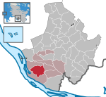
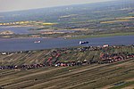
Lühesand is a small island of 1.24 square kilometres (0.48 sq mi) in the river Elbe (here the Lower Elbe), 8 kilometres (5.0 mi) east of Stade in Lower Saxony, Germany. The island, named after the easterly located mouth of the Lühe, forms part of Hollern-Twielenfleth (northwestern two thirds of the island) and Steinkirchen (southeastern third). It can only be reached by ferry from Grünendeich's westerly exclave Sandhörn and contains a large camping site, on which many continuous campers stay. The southern carrying pylons of Elbe Crossing 1 and Elbe Crossing 2 have been located on Lühesand.
Excerpt from the Wikipedia article Lühesand (License: CC BY-SA 3.0, Authors, Images).Lühesand
Lühesand, Samtgemeinde Lühe
Geographical coordinates (GPS) Address Nearby Places Show on map
Geographical coordinates (GPS)
| Latitude | Longitude |
|---|---|
| N 53.6 ° | E 9.5833333333333 ° |
Address
Lühesand
Lühesand
21723 Samtgemeinde Lühe, Siebenhöfen
Lower Saxony, Germany
Open on Google Maps


