place

Storm King Highway

Cornwall, New YorkHighlands, New YorkHudson RiverNational Register of Historic Places in Orange County, New YorkRoads in New York (state)
Roads on the National Register of Historic Places in New York (state)Transportation in Orange County, New York
NY 218 on Storm King

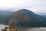
The Storm King Highway is a three-mile (4.8 km) segment of New York State Route 218 (NY 218) between Lee Road in the Town of Highlands at the south end and the Cornwall-on-Hudson village line in Orange County, New York, in the United States. It was built in 1916 and added to the National Register of Historic Places in 1982 in recognition of its accomplishment in civil engineering. It is so named because it winds around the steep slopes of Storm King Mountain near its north end of the Hudson Highlands on the west bank of the Hudson River. Here it reaches heights of up to 420 feet (130 m) above the water, with panoramic views of the river and surrounding mountains such as Breakneck Ridge and Bull Hill. Several small pullouts allow drivers to stop and enjoy the view. When built it took 22 miles (35 km) off the trip between Cornwall and Newburgh to its north with Highland Falls and West Point to its south. It remains in use by commuters, though a bypass, now part of US 9W, was built, further shortening travel times while still offering panoramic views.

Excerpt from the Wikipedia article Storm King Highway (License: CC BY-SA 3.0, Authors, Images).

Storm King Highway
Storm King Highway,

Geographical coordinates (GPS) Address External links Nearby Places
placeShow on map

Wikipedia: Storm King HighwayContinue reading on Wikipedia

Geographical coordinates (GPS)

Latitude Longitude
N 41.4175 ° E -73.973333333333 °
placeShow on map

Address

Storm King Highway

Storm King Highway
10996
New York, United States
mapOpen on Google Maps

linkWikiData (Q7620135)
linkOpenStreetMap (20711059)

NY 218 on Storm King
Share experience

Nearby Places

Cold Spring Historic District

The Cold Spring Historic District is a historic district that includes much of the central area of the Hudson River Cold Spring village in Putnam County, New York. It is roughly bounded by Main Street (in the northeastern portion of the village the eastern end of NY 301), Cedar and Fair streets and Paulding Avenue. It gives Cold Spring its quaint character and has been described as "one of the best-preserved 19th century townscapes in the Hudson River region". A consultants' report for the village's 1987 master plan quotes the National Register of Historic Places saying, upon adding the district in 1982: As a surviving industrial village, Cold Spring's commercial, ecclesiastical and residential features reflect the economic and social dynamics of the (early 19th century) era. The distinctive store structures on the broad Main Street, the noticeable contrast of house types and neighborhoods and the variety of religious institutions dominated by the foundry owner's donated Episcopal church, are the legacy of the prosperous and paternalistic society in nineteenth century Cold Spring. They are significant today for their architectural and historical associations to important events in the history of the Hudson Highlands Most of the houses, churches and other buildings came into existence in the years before the Civil War, when the nearby West Point Foundry was at the peak of its production and workers were rapidly moving into the area. Today the district includes over 200 buildings, many of them contributing properties. They have helped transform the village into a popular upscale residence for commuters and weekend destination for New York City residents due to the nearby Metro-North train station offering easy access to Grand Central Terminal.