place

Isaac Meason House

Houses completed in 1802Houses in Fayette County, PennsylvaniaHouses on the National Register of Historic Places in PennsylvaniaNational Historic Landmarks in PennsylvaniaNational Register of Historic Places in Fayette County, Pennsylvania
Use mdy dates from August 2023
Isaac Meason House
Isaac Meason House

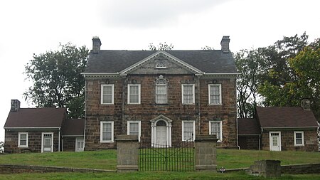
The Isaac Meason House, also known as Mount Braddock, is a historic house located in Dunbar Township, Fayette County, Pennsylvania. Completed in 1802, it is one of only two surviving Palladian style stone mansions from the period in the United States. Isaac Meason, for whom it was built, was an American Revolutionary War hero and early political power broker in the area, becoming the richest person in Fayette County due to his interest in iron furnaces. The house was designated a National Historic Landmark in 1990 for its architecture.

Excerpt from the Wikipedia article Isaac Meason House (License: CC BY-SA 3.0, Authors, Images).

Isaac Meason House
Cellurale Drive, Dunbar Township

Geographical coordinates (GPS) Address Nearby Places
placeShow on map

Wikipedia: Isaac Meason HouseContinue reading on Wikipedia

Geographical coordinates (GPS)

Latitude Longitude
N 39.953888888889 ° E -79.648055555556 °
placeShow on map

Address

Cellurale Drive 198
15456 Dunbar Township
Pennsylvania, United States
mapOpen on Google Maps

Isaac Meason House
Isaac Meason House
Share experience

Nearby Places

Joseph A. Hardy Connellsville Airport

Joseph A. Hardy Connellsville Airport (ICAO: KVVS, FAA LID: VVSformerly 2G3) is a public-use airport located four nautical miles (7 km) southwest of Connellsville in Dunbar Township, Fayette County, Pennsylvania, United States. It is owned by the Fayette County Airport Authority and serves the south-eastern segment of the Pittsburgh metropolitan area. The airport serves the general aviation community with no scheduled commercial airline service. The airport is named for Joseph A. Hardy, founder of 84 Lumber. Previously known as "Connellsville Airport," it was renamed in 2007 to recognize Hardy's support of improving the airport. Hardy, a Fayette County Commissioner at the time of the donation, gave the airport authority $800,000 for runway improvements.This airport is assigned a three-letter location identifier of VVS by the Federal Aviation Administration, but it does not have an International Air Transport Association (IATA) airport code.The airport property is home to other Fayette County entities and businesses: Fayette County Hazardous Materials (HAZMAT) Response Team. Fayette Area Coordinated Transportation (FACT). FACT is the main public bus service line for all of Fayette County with trips throughout the county each day. It occupies approximately 4.5 acres of property at the main entrance to the airport. Regional Stat MEDEVAC helicopter/air ambulance service, STAT MedEvac 5, a service of the Center for Emergency Medicine of Western Pennsylvania, Inc. is also located at the airport and rents space, buys fuel, and conducts maintenance on site. Connellsville Flying School Aero Aviation Training Center, LLC. Established in 2006 to provide flight training services to the public. Aviation Network, LLC. Established in 2008 to provide aviation management and maintenance. North Central Aviation, LLC. Established in 2003 to provide charter flights. The Washington Security Group, Inc. Established in 2004 to provide the training and consulting in specific national security areas.This airport also serves to provide a convenient stopping place for tourism in the region including those travelling to the following county historic and popular spots: Frank Lloyd Wright’s Falling Water, Mill Run, PA 15464 Frank Lloyd Wright’s Kentuck Knob, Chalk Hill, PA 15421 Ohiopyle, PA & Ohiopyle State Park Fort Necessity National Battlefield Nemacolin Woodlands Resort, Farmington, PA 15437