Garden District, New Orleans

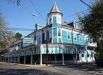
The Garden District is a neighborhood of the city of New Orleans, Louisiana, United States. A subdistrict of the Central City/Garden District Area, its boundaries as defined by the New Orleans City Planning Commission are: St. Charles Avenue to the north, 1st Street to the east, Magazine Street to the south, and Toledano Street to the west. The National Historic Landmark district extends a little farther.The area was originally developed between 1832 and 1900 and is considered one of the best-preserved collections of historic mansions in the Southern United States. The 19th-century origins of the Garden District illustrate wealthy newcomers building opulent structures based upon the prosperity of New Orleans in that era. (National Trust, 2006)
Excerpt from the Wikipedia article Garden District, New Orleans (License: CC BY-SA 3.0, Authors, Images).Garden District, New Orleans
Coliseum Street, New Orleans Garden District
Geographical coordinates (GPS) Address Nearby Places Show on map
 Continue reading on Wikipedia
 Geographical coordinates (GPS)
| Latitude | Longitude |
|---|---|
| N 29.927777777778 ° | E -90.084722222222 ° |
Address
Coliseum Street 2828
70115 New Orleans, Garden District
Louisiana, United States
Open on Google Maps