place

Redmires Reservoirs

Geography of SheffieldReservoirs in South YorkshireReservoirs of the Peak DistrictSouth Yorkshire geography stubsUse British English from July 2020
Water supply stubs
RedmiresUpper
RedmiresUpper

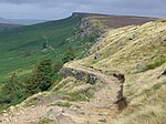
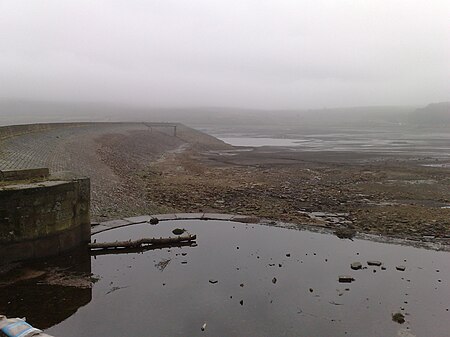
The Redmires Reservoirs are a group of three reservoirs in Fulwood, Sheffield, South Yorkshire, England. They are fed from the Hallam Moors by various small streams including Fairthorn Clough. The three reservoirs are named Upper, Middle and Lower and were built between 1833 and 1854 to provide clean drinking water via an open water course which led to the Hadfield Dam situated in Crookes, following the devastating Sheffield cholera epidemic of 1832. The dams were built as part of the Sheffield Water Works continuing expansion to meet the ever growing population of Sheffield. The area is popular with walkers and bird watchers. Adjacent to the Middle Reservoir is Hammond's Field Nature Reserve, which is managed by The Wildlife Trust for Sheffield and Rotherham. The nature reserve forms part of the South Pennine Moors Special Protected Area. A path, the Long Causeway leads from the Upper reservoir, onto the moors to Stanedge Pole and then onto Stanage Edge. This route was once thought to be a Roman road but is now thought to be a Medieval packhorse saltway, used to convey salt from Cheshire to Yorkshire.

Excerpt from the Wikipedia article Redmires Reservoirs (License: CC BY-SA 3.0, Authors, Images).

Redmires Reservoirs
Long Causeway, Sheffield

Geographical coordinates (GPS) Address Nearby Places
placeShow on map

Wikipedia: Redmires ReservoirsContinue reading on Wikipedia

Geographical coordinates (GPS)

Latitude Longitude
N 53.366 ° E -1.608 °
placeShow on map

Address

Long Causeway

Long Causeway
S10 4QZ Sheffield
England, United Kingdom
mapOpen on Google Maps

RedmiresUpper
RedmiresUpper
Share experience

Nearby Places

Stanedge Pole
Stanedge Pole

Stanedge Pole also known as Stanage Pole (grid reference SK2468784429) is a landmark on Hallam Moors close to Stanage Edge in South Yorkshire, England. Standing at a height of 438 metres (1,437 feet), it marks the border between Derbyshire and South Yorkshire and can be seen for several miles around. A pole has stood on the site since at least 1550. Many initials have been carved into the rock that supports it, and five can be identified as initials of the parish road surveyors who renewed the pole when needed. "T.C. 1550", "H.W. 1581", "T.M. 1631", "H.H. 1697" and "F.N. 1740" are the marks of the parish surveyors and the date the pole was renewed. The pole is a way marker on a medieval packhorse road known as the Long Causeway or Long Causey which runs west from Sheffield. It was used for centuries as a boundary marker between the parishes of Sheffield, Hathersage and Ecclesfield. Although it is widely believed the Long Causeway follows the line of a Roman road that ran from Templeborough Roman fort to the fort at Navio (Brough-on-Noe), archaeologists have cast doubt on this. There is some suggestion that the pole also marks the old boundary between Mercia and Northumberland. The top part of the pole was removed on Friday, 27 February 2015. A spokesperson for the Peak District National Park explained that "the wood on the top half of the pole was rotten and therefore a health and safety risk to the public. We had no choice but to make the pole safe by cutting off the top part.” On 17 April 2016 a group of people with an interest in the pole and surrounding environment, including the Peak District National Park Authority and the British Mountaineering Council, erected a new pole at the site to mark the 65th anniversary of the creation of the Peak District National Park. Support for the renewal also came from the Hope Cement Works, The Durham Foundry (Sheffield) Ltd, The Cutler's Company, Sheffield Clarion Ramblers and some public subscriptions. The new pole is formed from a locally felled larch tree, with a frame made by Hope Cement Works, and a base cast in Sheffield. The base is cast from ductile iron and has information cast into it (see photograph).

Burbage Rocks
Burbage Rocks

Burbage Rocks is a gritstone escarpment in South Yorkshire, overlooking the village of Hathersage in the Peak District. The highest point along the escarpment is 429 metres (1,407 ft) above sea level, whilst Burbage Moor rises above to 438 metres (1,437 ft). Burbage Rocks is a southern extension of Stanage Edge. Burbage Brook runs from the northern end of the Burbage Rocks, past the southern end, through Padley Gorge and into the RIver Derwent.The gritstone edge of Burbage Rocks is a popular rock climbing location. The Burbage Rocks North area is close to a car park and has 481 graded routes including many short, easy routes. The quieter Burbage South Edge area has 289 graded routes with much more challenging, long buttress climbs. Burbage South Quarries has a further 108 graded routes. The following routes on Burbage South Edge were climbed in the 1998 rock-climbing film Hard Grit: Samson (E8 7b) climbed by Jerry Moffatt Braille Trail (E7 6c) climbed by Dave Jones Parthian Shot (E9 7a) climbed by Seb Grieve Below Burbage Rocks (on Hathersage Moor to the west) are the hill Higger Tor and Carl Wark, the rocky platform of an Iron Age hillfort, which is a scheduled monument.Sheffield Country Walk is a 86 kilometres (53 mi) long trail which runs along the public footpath below the edge. Following the Countryside and Rights of Way Act 2000, the area of Burbage Rocks and surrounding moorland were designated as "Open Access" land for the public.