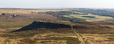
Carl Wark
Buildings and structures in SheffieldHill forts in South YorkshireHills and edges of South YorkshireHistory of SheffieldPeak District ... and 2 more
Scheduled monuments in South YorkshireUse British English from November 2018

Carl Wark (sometimes Carl's Wark) is a rocky promontory on Hathersage Moor in the Peak District National Park, just inside the boundary of Sheffield, England. The promontory is faced by vertical cliffs on all but one side, which is protected by a prehistoric embankment. The cliffs and embankment form an enclosure that has been interpreted as an Iron Age hill fort, though the date of construction and purpose of the fortifications remains unknown. The site is a scheduled monument.
Excerpt from the Wikipedia article Carl Wark (License: CC BY-SA 3.0, Authors, Images).Carl Wark
Packhorse Bridge, Sheffield
Geographical coordinates (GPS) Address Nearby Places Show on map
Geographical coordinates (GPS)
| Latitude | Longitude |
|---|---|
| N 53.329444444444 ° | E -1.6127777777778 ° |
Address
Carl Wark
Packhorse Bridge
S11 7TY Sheffield
England, United Kingdom
Open on Google Maps


