place

Brean Down

Bristol ChannelHeadlands of SomersetHill forts in SomersetHills of SomersetNational Trust properties in Somerset
Roman religious sites in EnglandScheduled monuments in SedgemoorSites of Special Scientific Interest in SomersetSites of Special Scientific Interest notified in 1971Use British English from July 2014
Brean Down
Brean Down

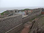
Brean Down is a promontory off the coast of Somerset, England, standing 318 feet (97 m) high and extending 1+1⁄2 miles (2.5 kilometres) into the Bristol Channel at the eastern end of Bridgwater Bay between Weston-super-Mare and Burnham-on-Sea. Made of Carboniferous Limestone, it is a continuation of the Mendip Hills. Two further continuations are the small islands of Steep Holm and Flat Holm. The cliffs on the northern and southern flanks of Brean Down have large quantities of fossils laid down in the marine deposits about 320–350 million years ago. The site has been occupied by humans since the late Bronze Age and includes the remains of a Romano-Celtic Temple. At the seaward end is Brean Down Fort which was built in 1865 and then re-armed in the Second World War. Brean Down is now owned by the National Trust, and is rich in wildlife, history and archaeology. It is a Site of Special Scientific Interest due to both the geology and presence of nationally rare plants including the white rock-rose. It has also been scheduled as an ancient monument.

Excerpt from the Wikipedia article Brean Down (License: CC BY-SA 3.0, Authors, Images).

Brean Down
Brean Down Road,

Geographical coordinates (GPS) Address Nearby Places
placeShow on map

Wikipedia: Brean DownContinue reading on Wikipedia

Geographical coordinates (GPS)

Latitude Longitude
N 51.3256 ° E -3.029 °
placeShow on map

Address

The Goldilocks Boulder

Brean Down Road
TA8 2RS , Brean
England, United Kingdom
mapOpen on Google Maps

Brean Down
Brean Down
Share experience

Nearby Places

Birnbeck Pier
Birnbeck Pier

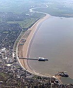
Birnbeck Pier, also known as the 'Old Pier', is a pier situated on the Bristol Channel in Weston-super-Mare, North Somerset, England, approximately 18 miles (29 km) south-west of Bristol. It is the only pier in the country which links the mainland to an island, linking to Birnbeck Island, a 1.2-hectare (3-acre) rocky island just to the west of Worlebury Hill. The grade II* listed pier was designed by Eugenius Birch and opened in 1867. Birnbeck Pier is one of only six Grade II* piers surviving in the country. The refreshment and waiting rooms of 1898 were designed by local architect Hans Price and the clocktower and the piermaster's house have been attributed to him. The pier has been closed to the public since 1994 and is now on the Buildings at Risk Register. During the second half of the 19th and early 20th centuries the pier was popular both with locals and tourists to the town. As a boarding point for steamers plying their trade in the Bristol Channel, it underwent various extensions and modifications over the years. During the Second World War the pier was commissioned as HMS Birnbeck by the Admiralty as part of the Directorate of Miscellaneous Weapons Development (DMWD) for research into new weapons. Notably conducting trials on the Barnes Wallis 'bouncing bomb'. The pier reopened after the war, but the number of visitors and steamer passengers declined. The final excursion visited the pier in 1979. Since its closure, ownership has changed many times and it has been subject to a series of proposals for its redevelopment which have all proved fruitless. The pier remains in a largely derelict state and part of it collapsed during storms in 2015. In 2023, the pier was purchased by North Somerset Council, with plans to restore it using funding from various sources.