place

Deanhead Reservoir

European lake stubsReservoirs in West YorkshireUnited Kingdom geography stubsUse British English from July 2016West Yorkshire geography stubs
Deanhead Reservoir
Deanhead Reservoir

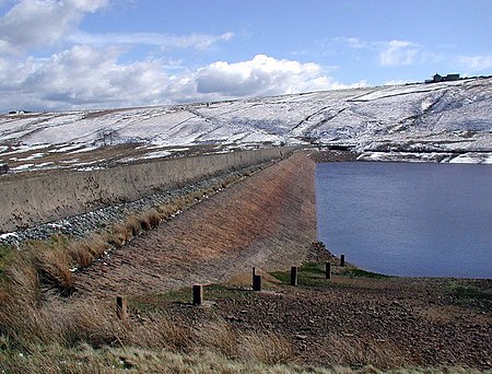
Deanhead Reservoir is a reservoir near Scammonden, in the metropolitan district of Kirklees, West Yorkshire, England. It is named after Dean Head, a village that was mostly submerged during construction of the dam. Construction started in 1838 and it opened a year later, almost 140 years before Scammonden Reservoir (its downstream neighbour) was opened in 1971. Water flowing out of Deanhead forms Black Burne Brook which now feeds into Scammonden Water. Deanhead reservoir was originally constructed to supply water to the factories in the Blackburn Valley that was downstream of the reservoir. During the 1995 drought, the outlines of foundations of buildings in the village were visible. Deanhead also is the name of a Pennine pass to the south of the reservoir, which carries the A640 from Huddersfield to Denshaw, following the course of a Roman road.

Excerpt from the Wikipedia article Deanhead Reservoir (License: CC BY-SA 3.0, Authors, Images).

Deanhead Reservoir
New Lane, Kirklees

Geographical coordinates (GPS) Address Nearby Places
placeShow on map

Wikipedia: Deanhead ReservoirContinue reading on Wikipedia

Geographical coordinates (GPS)

Latitude Longitude
N 53.632777777778 ° E -1.9441666666667 °
placeShow on map

Address

New Lane

New Lane
HX4 0DZ Kirklees
England, United Kingdom
mapOpen on Google Maps

Deanhead Reservoir
Deanhead Reservoir
Share experience

Nearby Places

Booth Wood Reservoir

Booth Wood Reservoir is a man-made upland reservoir that lies north of the M62 motorway and south of the A672 road near to Rishworth and Ripponden in Calderdale, West Yorkshire, England. The reservoir was approved for construction in 1966 and completed in 1971. It supplies water to Wakefield. The reservoir dams the Booth Dean Clough watercourse and takes water directly from the surrounding moorland. It has a plain concrete crest on the dam head which is straight and extends to a length of 1,150 feet (350 m) and a height of 157 feet (48 m).In 1995 a long dry spell in the summer created a larger than normal abstraction of water from Booth Wood creating the need to transport water into the reservoir as stocks ran very low. Road tankers carrying fresh water were despatched from Selby in North Yorkshire and Kielder Water in Northumberland to bring water for offloading at Booth Wood. At the height of the operation, 700 tankers delivered 70,000 tonnes (77,000 tons) of water a day to the reservoir which then fed other reservoirs in West Yorkshire.On 14 August 2016, the A672 road which runs along the northern edge of the reservoir was closed whilst police searched for a driver and car that had plunged off the road and into the reservoir. The driver was believed to be the only person in the car and the search operation involved helicopters and underwater divers. The search resumed the next day when a man's body was recovered.

Marsden Moor Estate
Marsden Moor Estate

The Marsden Moor Estate is a large expanse of moorland in the South Pennines, between the conurbations of West Yorkshire and Greater Manchester in the north of England. It is named after the adjacent town of Marsden, and is owned and administered by the National Trust to whom it was conveyed in 1955 by the Radcliffe family in lieu of death duties. The estate covers 2,429 ha (5,685 acres) of unenclosed common moorland and almost surrounds Marsden. Part of it is in the most northern section of the Peak District National Park. The landscape is made up of moorland, valleys, peaks and crags and has long been modified by man. Marsden is at the eastern gateway to the important ancient Standedge crossing of the moors and evidence of transport related archaeological remains dating from pre-Roman times have been discovered close to the great engineering structures of the canal and railway ages. The moors have been a water catchment area since the Victorian era when several reservoirs were built, along with their associated catchwaters in the Wessenden Valley. The Pennine Way and the Peak District Boundary Walk run across the moors (following the same route between Wessenden and Redbrook Reservoirs.The landscape supports large numbers of moorland birds such as the golden plover, red grouse, Eurasian curlew and twite. The estate, a designated Site of Special Scientific Interest, forms part of a Special Protection Area and is a candidate Special Area of Conservation.The estate is managed from a base in the old goods yard, adjacent to Marsden railway station, and the old goods shed has been converted into a public exhibition, entitled Welcome to Marsden, which gives an overview of the estate and its history.The moor has been affected by fires. Dozens of firefighters were required to put out a blaze in 2011. A fire in February 2019, during an unseasonal spell of warm weather, was described by West Yorkshire Fire and Rescue Service as one of the biggest moorland fires it had ever had to deal with.