Tel Hazor

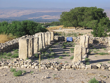
Tel Hazor (Hebrew: תל חצור), also Chatsôr (Hebrew: חָצוֹר), translated in LXX as Hasōr (Ancient Greek: Άσώρ), named in Arabic Tell Waqqas / Tell Qedah el-Gul (Arabic: تل القدح, romanized: Tell el-Qedah), is an archaeological tell at the site of ancient Hazor, located in Israel, Upper Galilee, north of the Sea of Galilee, in the northern Korazim Plateau. From the Middle Bronze Age (around 1750 BCE) to the Iron Age (ninth century BCE), Hazor was the largest fortified city in the region and one of the most important in the Fertile Crescent. It maintained commercial ties with Babylon and Syria, and imported large quantities of tin for the bronze industry. In the Book of Joshua, Hazor is described as "the head of all those kingdoms" (Josh. 11:10). Though scholars largely do not consider the Book of Joshua to be historically accurate, archaeological excavations have emphasized the city's importance. The Hazor expedition headed by Yigal Yadin in the mid-1950s was the most important dig undertaken by Israel in its early years of statehood. Tel Hazor is the largest archaeological site in northern Israel, featuring an upper tell of 30 acres and a lower city of more than 175 acres.In 2005, the remains of Hazor were designated a World Heritage Site by UNESCO as part of the Biblical Tels—Megiddo, Hazor, Beer Sheba.
Excerpt from the Wikipedia article Tel Hazor (License: CC BY-SA 3.0, Authors, Images).Tel Hazor
9118, Rosh Pina
Geographical coordinates (GPS) Address External links Nearby Places Show on map
Geographical coordinates (GPS)
| Latitude | Longitude |
|---|---|
| N 33.016666666667 ° | E 35.566944444444 ° |
Address
תל חצור
9118
1200000 Rosh Pina
North District, Israel
Open on Google Maps


