Lauriston Reservoir
North-Central catchmentReservoirs in Victoria (state)Rivers of Loddon Mallee (region)Victoria (state) geography stubs
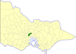
Lauriston Reservoir is a reservoir in Victoria, Australia, with a maximum capacity of 19,800 megalitres. The dam that created it, located 9 km west of Kyneton along Lauriston Reservoir Road, was constructed from 1938 to 1941 and has a spillway that measures 77 metres. The site is a popular picnic ground as one can fish there (although not from the dam structure itself), and barbecue facilities are available. The reservoir is known to contain redfin perch, rainbow and brown trout, roach and cod. The picnic and BBQ area near the dam wall at the end of Lauriston Reservoir Road are now free.
Excerpt from the Wikipedia article Lauriston Reservoir (License: CC BY-SA 3.0, Authors).Lauriston Reservoir
Lauriston Reservoir Road, Shire of Macedon Ranges
Geographical coordinates (GPS) Address Nearby Places Show on map
Geographical coordinates (GPS)
| Latitude | Longitude |
|---|---|
| N -37.254 ° | E 144.391 ° |
Address
Lauriston Reservoir Road
Lauriston Reservoir Road
3444 Shire of Macedon Ranges (Lauriston)
Victoria, Australia
Open on Google Maps


