place

Drummond, Victoria

Towns in Victoria (state)Use Australian English from August 2019Victoria (state) geography stubs
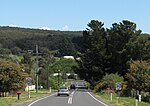
Drummond Town Entry Sign and War Memorial

Drummond is a locality in central Victoria, Australia. The locality is in the Shire of Hepburn, 106 kilometres (66 mi) north west of the state capital, Melbourne situated between Glenlyon to the south and Malmsbury to the north. At the 2016 census, Drummond had a population of 283.Drummond is home of the small rural Drummond Primary school and Drummond Public Hall.

Excerpt from the Wikipedia article Drummond, Victoria (License: CC BY-SA 3.0, Authors, Images).

Drummond, Victoria
Lauriston-Drummond Road, Shire of Hepburn

Geographical coordinates (GPS) Address Nearby Places
placeShow on map

Wikipedia: Drummond, VictoriaContinue reading on Wikipedia

Geographical coordinates (GPS)

Latitude Longitude
N -37.235555555556 ° E 144.32944444444 °
placeShow on map

Address

Korean War

Lauriston-Drummond Road
3446 Shire of Hepburn (Drummond)
Victoria, Australia
mapOpen on Google Maps

Drummond Town Entry Sign and War Memorial
Share experience

Nearby Places

Malmsbury Viaduct
Malmsbury Viaduct

The Malmsbury Viaduct is a large brick and stone masonry arch bridge over the Coliban River at Malmsbury on the Bendigo Railway in Victoria Australia. It was erected as part of the Melbourne, Mount Alexander and Murray River Railway between 1858 and 1861, and was at the time the largest masonry arch railway bridge built in Victoria. Construction of the Bendigo line commenced under the Melbourne, Mount Alexander and Murray River Railway Company in 1858, but this private consortium met with financial difficulties when it was unable to raise sufficient funds, and was bought out by the Victorian colonial government in 1860 when it formed the Victorian Railways Department.The contract for the first stage of the line from Footscray to Sandhurst (now Bendigo), was let to Cornish and Bruce for £3,356,937.2s.2d ($6.714 million) with work commencing on 1 June 1858. Completion of the permanent way was to be by 31 July 1861.The design work was then taken over by Captain Andrew Clarke, R. E., Surveyor-General of Victoria, with the bridge designs completed by William Bryson CE, Head Draftsman, who was responsible for many of the large structures such including bridges and viaducts under the supervision of George Christian Darbyshire for the Victorian Railway. William O’Hara, Senior Draftsman with the railways department, also had experience in the design of masonry structures and so probably also contributed to the design of the viaduct.The bridge is over 100m long with five 18.3 metre spans, standing about 25 metres high. 132,000 cubic feet of bluestone for the bridge was quarried at the east end of Malmsbury and carted to the site by horse and drays.The foundation stone for the viaduct was laid on 25 October 1859 and the bridge was completed on 24 October 1860. It was listed on the Victorian Heritage Register in May 2000.A celebration of the 150th anniversary of this event was held in 2010 organised by the Malmsbury Historical Society.

Glenlyon, Victoria
Glenlyon, Victoria

Glenlyon is a small village in the Shire of Hepburn local government area, Victoria, Australia around 10 km from Daylesford along the Daylesford–Malmsbury Road, and around 101 km from the Melbourne CBD via Kyneton and Malmsbury. It is on the Loddon River. Glenlyon is well known for its main street of old European trees lending an "Englishness" to the village and providing a cooling canopy in the heat of summer. As at the 2016 Commonwealth Census, the village of Glenlyon & its immediate hinterland (the census district includes the localities/hamlets of Denver, Porcupine Ridge, parts of Wheatsheaf) had a population of 389 people. The median age of the local population is 50 as of 2011. The top 5 cultural backgrounds of the local population are broken up into 30% claiming English heritage, 20% Australian heritage, 13.5% Irish, 11.9% Scottish and 3.3% Germany—however, of these numbers, 74.9% were actually born in Australia, 5.8% in England and 3% in New Zealand. 84.7% only spoke English at home. A reflection of the village as the location of many commuters to either Daylesford, Ballarat or even Melbourne and reflecting the fact that the locale is a popular retirement, weekender, holiday home or hobby farm location is that 44.1% are employed in professional or managerial roles with 13.9% as tradesmen and 21.9% as clerical or public servants. Only 6.6% work in rural or farming.Glenlyon has a rich agricultural industry amongst the surrounding areas. Cattle and sheep are largely stocked throughout the district supplying meat products and wool to the local and global markets. Potatoes, cereal crops (both for hay and grain), organic vegetables, vegetable seed and lucerne grow in the rich volcanic soil. The contrast of green pastures, grazing livestock, bright red ploughed paddocks and golden stubble paddocks across the rolling countryside, make the scenery in the area very special to the locals and visitors alike.

Tachylite in Victorian archaeological sites

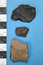
Tachylite is an unusual and relatively rare stone used in making flaked stone tools, and which is found in Aboriginal archaeological sites in Victoria, Australia.It was sourced from Spring Hill near Lauriston, Victoria, and there is another historical reference to a source at Green Hill near Trentham, Victoria, but the exact location has not been confirmed. Daniel James Mahony described ...water worn pebbles of pitchstone, a highly silicious volcanic glass associated with tachylite on the Coliban River. Mitchell refers to the distribution of the material with: Small artefacts are common at Willaura, Burrumbeet, Inverleigh, Point Cook and as far north as Dooen near Horsham.Since 2016 the material is found on further sites on the traditional lands of the Dja Dja Wurrung who were well regarded by other groups for the hard glassy stone that all valued and traded to use for superior stone weapons and tools. Examples are held in the collection of the Castlemaine Art Museum. Tachylite is a type of volcanic opaque glass, and is applied to basalts with a glassy matrix that contain scattered small phenocrysts (pyroxene, plagioclase, olivine). Aboriginal artefacts flaked from the material are characterised by a black internal colour, which is very often patinated on the surface to a pale grey. This patina rapidly darkens on contact with the skin, turning as dark as the core. Only a few pieces are generally found in archaeological assemblages in southern Victoria and around Melbourne, apart from at sites near Spring Hill, Kyneton, where it is the most common material.Tachylite artefacts have been noted in Aboriginal sites in Victoria from at least the 1920s, when W. H. Gill recorded its occurrence in a large stone artefact and camp site complex at Cape Liptrap.Tachylite has also been identified as a material used in manufacturing flaked stone artefacts in archaeological sites in Europe, North America, and India.