place

Millington, Connecticut

East Haddam, ConnecticutHistoric districts in Middlesex County, ConnecticutHistoric districts on the National Register of Historic Places in ConnecticutNRHP infobox with nocatNational Register of Historic Places in Middlesex County, Connecticut
Use mdy dates from July 2023Villages in ConnecticutVillages in Middlesex County, Connecticut
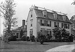
10th District Schoolhouse, Millington CT

Millington is a village within the town of East Haddam, Connecticut. Millington lies halfway between East Haddam center and Salem center. It is the section of East Haddam that is the closest to Devil's Hopyard State Park. The village is connected to East Haddam Center and to Devil's Hopyard State Park by a series of secondary roads that are maintained by the state. The road is given an unsigned designation "Special Service Road 434", which runs on Mount Parnassus Road, Millington Road, Haywardville Road, and Hopyard Road. Millington includes the Millington Green Historic District which was listed on the National Register of Historic Places in 1996.The village is the site of the Millington Green, a small triangular town green in the center of the village at the junction of Millington, Haywardville, and Tater Hill roads. The Green contains a flagpole, bench, and perennial flower garden and is surrounded by several historic houses, including the Daniel Bulkeley House (built in 1792), the 10th District Schoolhouse (built in 1854), the Millington Green Parsonage (built in 1854), the Julius Schwab House (built in 1950 but incorporating a schoolhouse from 1756), and the Ebenezer Dutton House (built in 1766).Millington was first settled in 1704 by Jonathan Beebe of New London. An ecclesiastical society separate from Haddam (East Haddam was then part of Haddam) was granted in 1733. The congregational church was organized in 1736 and a meetinghouse constructed on the Green in 1740. The village became a training area for the local militia during the Revolutionary War. The village never recovered from a depression following the War of 1812 and is now a rural residential neighborhood.

Excerpt from the Wikipedia article Millington, Connecticut (License: CC BY-SA 3.0, Authors, Images).

Millington, Connecticut
Millington Road,

Geographical coordinates (GPS) Address Nearby Places
placeShow on map

Wikipedia: Millington, ConnecticutContinue reading on Wikipedia

Geographical coordinates (GPS)

Latitude Longitude
N 41.485 ° E -72.358333333333 °
placeShow on map

Address

Millington Road 79
06423
Connecticut, United States
mapOpen on Google Maps

10th District Schoolhouse, Millington CT
Share experience

Nearby Places

Lake Hayward (Connecticut)

Lake Hayward is a natural spring-fed lake situated just north of Devil's Hopyard State Park in the northeastern corner of East Haddam, Connecticut, and is bordered by the towns of Colchester and Salem. Lake Hayward, once known as Long Pond (by the native tribes who inhabited its shores) and then Shaw Lake, is named for Nathaniel Hayward. In 1838, Charles Goodyear, of the Goodyear Tire and Rubber Company, and Nathaniel Hayward were partners in a rubber mill which operated in Massachusetts. In 1847 after breaking away from Goodyear's company, Mr. Hayward established a factory in Colchester, Connecticut to manufacture shoes. Mr. Hayward remained in Colchester, Connecticut, until his death in the 1860s. During the time he was residing in Colchester, he purchased land for hunting along Shaw's pond on the north east edge of East Haddam, Connecticut, where a grist mill was operating. After Nathaniel Hayward's death, Shaw's Pond was renamed Lake Hayward in his honor, as well as Hayward Avenue in Colchester.Lake Hayward is approximately 1.5 miles (2.4 km) long and 0.5 miles (0.8 km) wide. Its surface area is 174 acres (70 ha), and its elevation is 348 feet (106 m) above sea level. The lake has an average depth of 11 feet (3.4 m) and a maximum depth of 37 feet (11 m). The lake has four private beaches and does not allow motorboats with gasoline engines. The western side of the lake is overseen and monitored by the local homeowners association, the Property Owners Association of Lake Hayward (POALH). There are both year-round and summer homes in the area.

Working Girls' Vacation Society Historic District

The Working Girls' Vacation Society Historic District is a 27-acre (11 ha) historic district in East Haddam, Connecticut that was listed on the National Register of Historic Places in 1994. It is significant by dint of the properties having been owned, during 1892–1945, by the Working Girls' Vacation Society of New York City, and used as a summer retreat for working women from the city. The society is similar to the Young Women's Christian Association, founded in 1866, in that it is one of many organizations intending to "minister to the 'temporal, moral and religious welfare of self-supporting women.' Led by enlightened upper class philanthropist/reformers such as copper heiress Grace Dodge, a national network of "working girls' clubs" formed in the 1880s. Their mission primarily was to protect the morality of working women, rather than to improve the conditions of the workplace (note 4); their means included the creation of opportunities for social intercourse, self-improvement (education), and recreation in a morally uplifting setting. The New York Working Girls' Club, founded by Dodge in 1883 and the first of its kind in the nation, maintained, for example, a clubhouse with a library and extensive series of lectures, classes, and social events (note 5). The employment-related health needs of working girls were not ignored. The Working Girls' Vacation Society of New York, an offshoot of the Working Girls' Club, was founded in 1883 to provide summer vacations in the country for women with demonstrated health problems. The founders of the society included prominent upper-class women and social workers (note 6). In a pattern repeated in other cities, the Vacation Society made available low-cost stays generally of two weeks in duration at rural locations (note 7)."A total of 411 working girls were assisted by the society in the summer of 1884. By 1915 the society had created several retreats in Connecticut and served 1450.The district includes three side-by-side properties on a rural road in East Haddam, Connecticut, with three houses and three barns.When listed, the district included six contributing buildings and one non-contributing building. Three of the six are residences. The Phebe Howell House (c.1835), is constructed with pegged post-and-beam framing, and shows what may be its original clapboard siding. It and the Charles Howell House (c.1825) are constructed on granite ashlar foundations. The latter's doorway is flanked by fluted pilasters. A vernacular bungalow house (c.1915) is the other.The three other contributing buildings are 19th-century, wood-frame barns. The one at 66 Mill Road (photograph 5 in accompanying photos) "is similar in size and design to the ell on the Phebe Howell House, which tends to confirm oral history that this barn was formerly attached to the rear of the Charles Howell House."DiNapoli, writing in 1892, describes the working girls' plight.The association renamed in 1950 to become the Katherine Herbert Fund, named after the 1885 founder of the society. In 1974 it merged with the Stony Wold Corporation, an organization that had focused upon tuberculosis, to become the Stony Wold-Herbert Fund.