place

Cresson, Pennsylvania

Boroughs in Cambria County, PennsylvaniaPopulated places established in 1902
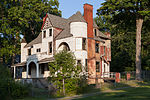
Second from Ashcroft, Cresson

Cresson is a borough in Cambria County, Pennsylvania, United States. Cresson is 80 miles (130 km) east of Pittsburgh. It is above 2,000 feet (600 m) in elevation. Lumber, coal, and coke yards were industries that had supported the population, which numbered 1,470 in 1910. The borough is part of the Johnstown Metropolitan Statistical Area, although state and local sources list it as part of the Altoona area due to being much closer to that city. The population of Cresson at the 2010 census was 1,711.The location was named in 1854 as a memorial to philanthropist Elliott Cresson. Railroads, beginning with the Allegheny Portage Railroad, fueled the growth of the area. Many famous Pittsburgh businessmen, including Charles M. Schwab, Andrew Carnegie, and Henry Clay Frick, maintained summer residences in the area. The borough was incorporated in 1906, along with neighboring Sankertown.

Excerpt from the Wikipedia article Cresson, Pennsylvania (License: CC BY-SA 3.0, Authors, Images).

Cresson, Pennsylvania
Eckley Alley,

Geographical coordinates (GPS) Address Nearby Places
placeShow on map

Wikipedia: Cresson, PennsylvaniaContinue reading on Wikipedia

Geographical coordinates (GPS)

Latitude Longitude
N 40.4625 ° E -78.586388888889 °
placeShow on map

Address

Eckley Alley

Eckley Alley
16630
Pennsylvania, United States
mapOpen on Google Maps

Second from Ashcroft, Cresson
Share experience

Nearby Places

Blair Gap
Blair Gap

Blair Gap, one of the gaps of the Allegheny, is a water gap along the eastern face atop the Allegheny Front escarpment. Like other gaps of the Allegheny, the slopes of Blair Gap were amenable to foot travel, pack mules, and possibly wagons allowing Amerindians, and then, after about 1778–1780 settlers, to travel west into the relatively depopulated Ohio Country decades before the railroads were born and tied the country together with steel. The gap was used historically for the upper sections of the Allegheny Portage Railroad, which as was authorized by the enabling acts in 1824 of Pennsylvania's Main Line of Public Works as part of the Pennsylvania Canal System which originally envisioned linking Pittsburgh to Philadelphia by canals. In the early 1900s, U.S. Route 22 followed alongside the watercourse through the gap. Until the 1920s, after new founded auto clubs gathered enough numbers to political clout to push for initiatives creating roads between towns, off the railroads the primary means of travel town to town was on foot or where hauling was needed, using wagons. There were only five ways through the Appalachians east to west: Around the bottom (plains or Piedmont area) in Georgia, the Cumberland Gap, the Cumberland Narrows, the gaps of the Allegheny Front, and up the Hudson River then around the north end of the Catskills and across Upstate New York to the Great Lakes. All other transits involve difficult climbs a man on foot can only make with great difficulty, and which animal drawn transport could not. Geographically and geologically, without the large projects and engineering capabilities of the 20th century, there were exactly three internal regions where it was possible to get animal powered vehicles from the east side to the west side of the Appalachian Mountains, making five routes overall counting traveling around the plains at either end of the western chain. Below Canada, the geologic nature of successive barrier ridges of the Ridge and Valley Appalachians runs from the valley of the Hudson, the Delaware Water Gap down through all of northern Pennsylvania, sundering eastern and central Pennsylvania, Maryland, North Carolina, Virginia, Western Pennsylvania, West Virginia, Kentucky, and Tennessee.

Allegheny Portage Railroad

The Allegheny Portage Railroad was the first railroad constructed through the Allegheny Mountains in central Pennsylvania. It operated from 1834 to 1854 as the first transportation infrastructure through the gaps of the Allegheny that connected the midwest to the eastern seaboard across the barrier range of the Allegheny Front. Approximately 36 miles (58 km) long overall, both ends connected to the Pennsylvania Canal, and the system was primarily used as a portage railway, hauling river boats and barges over the divide between the Ohio and the Susquehanna Rivers. Today, the remains of the railroad are preserved within the Allegheny Portage Railroad National Historic Site operated by the National Park Service. The railroad was authorized as part of the Main Line of Public Works legislation in 1824. It had five inclines on either side of the drainage divide running athwart the ridge line from Blair Gap through along the kinked saddle at the summit into Cresson, Pennsylvania. The endpoints connected to the Canal at Johnstown on the west through the relative flats to Hollidaysburg on the east. The Railroad utilized cleverly designed wheeled barges to ride a narrow-gauge rail track with steam-powered stationary engines lifting the vehicles. The roadbed of the railroad did not incline monotonically upwards, but rose in relatively long, saw-toothed stretches of slightly-sloped flat terrain suitable to animal powered towing, alternating with steep cable railway inclined planes using static steam engine powered windlasses, similar to mechanisms of modern ski lifts. Except for peak moments of severe storms, it was an all-weather, all-seasons operation. Along with the rest of the Main Works, it cut transport time from Philadelphia to the Ohio River from weeks to just 3–5 days. Considered a technological marvel in its day, it played a critical role in opening the interior of the United States beyond the Appalachian Mountains to settlement and commerce. It included the first railroad tunnel in the United States, the Staple Bend Tunnel, and its inauguration was marked with great fanfare.