Wardle, Cheshire
Civil parishes in CheshireVillages in Cheshire

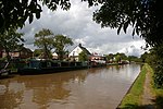
Wardle is a village and civil parish in the unitary authority of Cheshire East and the ceremonial county of Cheshire, England. The village lies on the Shropshire Union Canal, north west of Barbridge Junction (at SJ610570), and is 4 miles to the north west of Nantwich, and the parish also includes part of the small settlement of Wardle Bank. The total population is around 250. RAF Calveley was a flight-training station during the Second World War, and the Mark III radio telescope stood on the airfield site in 1966–96. The modern civil parish includes Wardle Industrial Estate and is otherwise largely agricultural. Nearby villages include Barbridge, Calveley and Haughton.
Excerpt from the Wikipedia article Wardle, Cheshire (License: CC BY-SA 3.0, Authors, Images).Wardle, Cheshire
Wardle Avenue,
Geographical coordinates (GPS) Address Nearby Places Show on map
Geographical coordinates (GPS)
| Latitude | Longitude |
|---|---|
| N 53.11 ° | E -2.583 ° |
Address
Wardle Avenue
CW5 6BQ
England, United Kingdom
Open on Google Maps


