place

Scottsville, New York

Rochester metropolitan area, New YorkUse mdy dates from July 2023Villages in Monroe County, New YorkVillages in New York (state)
Monroe County New York incorporated and unincorporated areas Scottsville highlighted

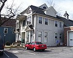
Scottsville is a village in southwestern Monroe County, New York, United States, and is in the northeastern part of the Town of Wheatland. The population was 2,009 at the 2020 Census. The village is named after an early settler, Isaac Scott. Most Scottsvillians work in and around the city of Rochester—the village of Scottsville is located about a ten-minute drive from the outer limits of the city.

Excerpt from the Wikipedia article Scottsville, New York (License: CC BY-SA 3.0, Authors, Images).

Scottsville, New York
Ritterstraße,

Geographical coordinates (GPS) Address Website Nearby Places
placeShow on map

Wikipedia: Scottsville, New YorkContinue reading on Wikipedia

Geographical coordinates (GPS)

Latitude Longitude
N 43.021944444444 ° E -77.753611111111 °
placeShow on map

Address

Duborg-Skolen

Ritterstraße 27
24939 , Westliche Höhe
Schleswig-Holstein, Deutschland
mapOpen on Google Maps

Website
duborg-skolen.dk

linkVisit website

Monroe County New York incorporated and unincorporated areas Scottsville highlighted
Share experience

Nearby Places

Oatka Creek
Oatka Creek

Oatka Creek ( oh-AT-kə) is the third longest tributary of the Genesee River, located entirely in the Western New York region of the U.S. state of New York. From southern Wyoming County, it flows 58 miles (93 km) to the Genesee near Scottsville, draining an area of 215 square miles (560 km2) that includes all or part of 23 towns and villages in Wyoming, Genesee, Livingston and Monroe counties as well. Its name means "leaving the highlands" or "approaching an opening" in Seneca. Like its parent stream it originated during the end of the last Ice Age, as glacial impact on the upper Allegheny Plateau created a rolling landscape streams could gradually erode through, The Oatka carved a deep groove known today as the Oatka Valley, where the upper creek's two major settlements would be established. Native Americans of the Seneca nation established a few settlements along it where clearings arose in the forest. The Revolutionary War's Sullivan Expedition, brought the valley's fertile soil to the attention of the emerging nation, and the region was opened for settlement shortly after the war. For a time the Oatka was called Allan's Creek after the area's first settler, Ebenezer "Indian" Allan. Its waterpower facilitated early 19th-century European settlement of the abundant fertile lands in the Holland Purchase. Today it remains an important regional resource, used for water supply and recreational purposes, and actively protected to assure water quality. It is a popular trout stream, stocked from the oldest fish hatchery in the Western Hemisphere near its mouth. A dam in Le Roy makes the section below it a losing stream, dry during the warm months of the year as the stream flows through subterranean channels.