place

Cox–Budlong House

Federal architecture in New York (state)Greek Revival architecture in New York (state)Houses completed in 1820Houses in Monroe County, New YorkHouses on the National Register of Historic Places in New York (state)
Italianate architecture in New York (state)Monroe County, New York Registered Historic Place stubsNational Register of Historic Places in Monroe County, New York
CoxBudlongHouseWheatlandNewYork

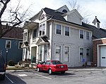
The Cox–Budlong House is a historic house at 4396 River Road near Scottsville, Monroe County, New York.

Excerpt from the Wikipedia article Cox–Budlong House (License: CC BY-SA 3.0, Authors, Images).

Cox–Budlong House
River Road, Town of Wheatland

Geographical coordinates (GPS) Address Nearby Places
placeShow on map

Wikipedia: Cox–Budlong HouseContinue reading on Wikipedia

Geographical coordinates (GPS)

Latitude Longitude
N 43.01383 ° E -77.74671 °
placeShow on map

Address

River Road 4396
14546 Town of Wheatland
New York, United States
mapOpen on Google Maps

CoxBudlongHouseWheatlandNewYork
Share experience

Nearby Places

Oatka Creek
Oatka Creek

Oatka Creek ( oh-AT-kə) is the third longest tributary of the Genesee River, located entirely in the Western New York region of the U.S. state of New York. From southern Wyoming County, it flows 58 miles (93 km) to the Genesee near Scottsville, draining an area of 215 square miles (560 km2) that includes all or part of 23 towns and villages in Wyoming, Genesee, Livingston and Monroe counties as well. Its name means "leaving the highlands" or "approaching an opening" in Seneca. Like its parent stream it originated during the end of the last Ice Age, as glacial impact on the upper Allegheny Plateau created a rolling landscape streams could gradually erode through, The Oatka carved a deep groove known today as the Oatka Valley, where the upper creek's two major settlements would be established. Native Americans of the Seneca nation established a few settlements along it where clearings arose in the forest. The Revolutionary War's Sullivan Expedition, brought the valley's fertile soil to the attention of the emerging nation, and the region was opened for settlement shortly after the war. For a time the Oatka was called Allan's Creek after the area's first settler, Ebenezer "Indian" Allan. Its waterpower facilitated early 19th-century European settlement of the abundant fertile lands in the Holland Purchase. Today it remains an important regional resource, used for water supply and recreational purposes, and actively protected to assure water quality. It is a popular trout stream, stocked from the oldest fish hatchery in the Western Hemisphere near its mouth. A dam in Le Roy makes the section below it a losing stream, dry during the warm months of the year as the stream flows through subterranean channels.