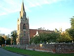
Southcote ( (listen)) is a suburb of Reading in the English county of Berkshire. Located to the south-west of Reading town centre, Southcote has a population of about 8,500 (as of 2011). The settlement lies primarily between the London-to-Bath road and the River Kennet.
The area was sparsely populated until after the Second World War, though excavations have revealed evidence of Paleolithic and Iron Age activity in Southcote, as well as Roman and Saxon habitation. By the time William the Conqueror undertook the Domesday Survey in 1086, Southcote was sufficiently established to warrant a Lord of the Manor, who at that time was William de Braose. From the 16th century onwards, Southcote Manor was owned by the Blagrave family, who sold the manor house in the 1920s. The area was subsequently developed into housing: much of the land changed from agricultural to residential. A large proportion of the land in Southcote not used for housing is classified as flood-meadow, providing flood plains between urbanisation and the River Kennet.
Southcote forms an electoral ward in Reading. The area is seen as a safe seat for Labour, as the Conservatives have not held a seat on the council since the 1980s.
Residents of Southcote generally self-classify as Christian. The male life expectancy in the area is lower than the national estimate, although the female expectancy is slightly higher. Claimants of out-of-work benefits (such as Jobseeker's Allowance) are more prevalent in Southcote than in surrounding areas. Attainment in education in Southcote is lower than the Reading average, as is residents' self-evaluation of health.
Near to the settlement is Southcote Junction, where the Great Western Main Line diverges into the Reading to Taunton line and the Reading to Basingstoke line. The railways were preceded by the Kennet and Avon Canal, which passes south of the settlement. Southcote lends its name to the 104th lock on the canal.


