Helgalunden
Geography of Stockholm
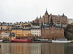
Helgalund, Helgalunden, or Tjurberget, is a neighbourhood on the island Södermalm in Stockholm, Sweden. The picturesque area was designed by architect and city planner Per Olof Hallman, c. 1930. The neighbourhood is located on the hill Tjurberget with parks in the north and south. At the centre of Helgalund is Allhelgonakyrkan, the "Church of all saints," in the grove Helgalunden, from which the area takes its name. The eight groves of Rosenlundsparken, Tjurbergsgatan, Blekingegatan, Götgatan, Dalslandsgatan, Tjurberget, Assesorsgatan, and Grindsgatan roughly make up the borders of the area.
Excerpt from the Wikipedia article Helgalunden (License: CC BY-SA 3.0, Authors).Helgalunden
Oranienburger Straße, Berlin Mitte
Geographical coordinates (GPS) Address Nearby Places Show on map
Geographical coordinates (GPS)
| Latitude | Longitude |
|---|---|
| N 59.31 ° | E 18.070833333333 ° |
Address
Postfuhramt
Oranienburger Straße 35-36
10117 Berlin, Mitte
Berlin, Deutschland
Open on Google Maps


