place

Downtown, Providence, Rhode Island

Central business districts in the United StatesGeography of Providence, Rhode IslandHistoric American Buildings Survey in Rhode IslandHistoric districts in Providence County, Rhode IslandHistoric districts on the National Register of Historic Places in Rhode Island
NRHP infobox with nocatNational Register of Historic Places in Providence, Rhode IslandNeighborhoods in Providence, Rhode IslandUse mdy dates from October 2020Vague or ambiguous time from February 2022
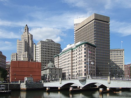
Downtown Providence Rhode Island 2008

Downtown is the central economic, political, and cultural district of the city of Providence, Rhode Island. It is bounded on the east by Canal Street and the Providence River, to the north by Smith Street, to the west by Interstate 95, and to the south by Henderson Street. The highway serves as a physical barrier between the city's commercial core and neighborhoods of Federal Hill, West End, and Upper South Providence. Most of the downtown is listed on the National Register of Historic Places as the Downtown Providence Historic District.

Excerpt from the Wikipedia article Downtown, Providence, Rhode Island (License: CC BY-SA 3.0, Authors, Images).

Downtown, Providence, Rhode Island
Clifford Street, Providence

Geographical coordinates (GPS) Address Nearby Places
placeShow on map

Wikipedia: Downtown, Providence, Rhode IslandContinue reading on Wikipedia

Geographical coordinates (GPS)

Latitude Longitude
N 41.82 ° E -71.41 °
placeShow on map

Address

Trinity Presbyterian Church

Clifford Street
02903 Providence
Rhode Island, United States
mapOpen on Google Maps

Downtown Providence Rhode Island 2008
Share experience

Nearby Places

Hay and Owen Buildings

The Hay and Owen Buildings are a pair of historic commercial buildings in Providence, Rhode Island. The Owen Building (101 Dyer Street) was built in 1866 as two buildings, with a narrow alley running between them. They were designed by Alfred Stone for George and Smith Owen (G. & S. Owen), whose sons operated a wholesale yarn business on the premises. In 1877 Stone, as Stone & Carpenter, returned to remodel the buildings. The southern part, a four-story, nine-bay building, remained as it was built in 1866. In contrast, the northern part was radically changed. It was extended to meet the southern part, and a new fifth floor was added. A great deal of new ornamentation was also added at this time. Thus, the plural Owen Buildings became the Owen Building. The two parts originally met in the same way on both the east and west elevations. The original design remains on the west, but the east side was filled in with a flat brick wall sometime between 1918 and 1937.The Hay Building (117-135 Dyer Street) is a four-story structure, built in 1867 for Alexander Duncan, as a speculative business venture. It was designed by James C. Bucklin. The Hay Building was formerly the Hay Buildings, as a matching structure once stood on the parking lot behind the building. Despite its mansard roof, the otherwise plain design of the building recalls Bucklin's earlier Greek Revival designs. The two buildings are survivors of the era when the Weybosset Hill area was a center of Providence's commercial port.The buildings were listed on the National Register of Historic Places in 1982.