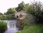
Grafton Lock
Locks on the River ThamesOxfordshire geography stubsUse British English from April 2017West Oxfordshire District

Grafton Lock is a lock on the River Thames in Oxfordshire, England. It is on the northern bank between Kelmscott and Radcot, about 1 mile (1.6 km) south of the hamlet of Grafton. The lock was built by the Thames Conservancy in 1896. The weir is on the other side of the lock island at the upstream end. Grafton Lock Meadow at the lock is a Site of Special Scientific Interest.
Excerpt from the Wikipedia article Grafton Lock (License: CC BY-SA 3.0, Authors, Images).Grafton Lock
B4449, West Oxfordshire Grafton and Radcot
Geographical coordinates (GPS) Address Nearby Places Show on map
Geographical coordinates (GPS)
| Latitude | Longitude |
|---|---|
| N 51.6909 ° | E -1.60935 ° |
Address
B4449
GL7 3HD West Oxfordshire, Grafton and Radcot
England, United Kingdom
Open on Google Maps


