St John's, Woking
Use British English from July 2016Villages in Surrey

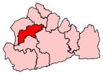
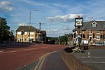
St Johns and Hook Heath is a suburban ward in Surrey consisting of two settlements founded in the 19th century in the medieval parish of Woking. The two 'villages' have residents' associations and are centred 2.5 km WSW and SW of Woking's town centre in the northwest of the English county – by including such suburbs, Woking is the largest town in the county. The ward in 2011 contained 1,888 homes across its 3.46 square kilometres (1.34 sq mi).
Excerpt from the Wikipedia article St John's, Woking (License: CC BY-SA 3.0, Authors, Images).St John's, Woking
Geographical coordinates (GPS) Address Nearby Places Show on map
Geographical coordinates (GPS)
| Latitude | Longitude |
|---|---|
| N 51.311 ° | E -0.594 ° |
Address
GU21 7RN , Hook Heath
England, United Kingdom
Open on Google Maps


